You are here: Home > Network List > IC - New China Digital Seismograph Network Stations List
> Station ENH Enshi, Hubei Province, China > Earthquake Result Viewer
ENH Enshi, Hubei Province, China - Earthquake Result Viewer

| Earthquake location: |
Kermadec Islands Region |
| Earthquake latitude/longitude: |
-27.4/-176.3 |
| Earthquake time(UTC): |
2009/02/18 (049) 21:53:45 GMT |
| Earthquake Depth: |
25 km |
| Earthquake Magnitude: |
6.8 MB, 7.2 MS, 6.9 MW, 6.9 MW |
| Earthquake Catalog/Contributor: |
WHDF/NEIC |
|
| Network: |
IC New China Digital Seismograph Network |
| Station: |
ENH Enshi, Hubei Province, China |
| Lat/Lon: |
30.27 N/109.49 E |
| Elevation: |
487 m |
|
| Distance: |
91.2 deg |
| Az: |
303.641 deg |
| Baz: |
121.196 deg |
| Ray Param: |
0.04161956 |
| Estimated Moho Depth: |
59.5 km |
| Estimated Crust Vp/Vs: |
1.62 |
| Assumed Crust Vp: |
6.083 km/s |
| Estimated Crust Vs: |
3.766 km/s |
| Estimated Crust Poisson's Ratio: |
0.19 |
|
| Radial Match: |
93.08846 % |
| Radial Bump: |
400 |
| Transverse Match: |
92.528595 % |
| Transverse Bump: |
400 |
| SOD ConfigId: |
2658 |
| Insert Time: |
2010-03-04 21:49:52.400 +0000 |
| GWidth: |
2.5 |
| Max Bumps: |
400 |
| Tol: |
0.001 |
|
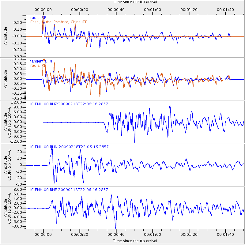
Signal To Noise
| Channel | StoN | STA | LTA |
| IC:ENH:00:BHN:20090218T22:06:16.285Z | 109.49809 | 1.0185425E-5 | 9.30192E-8 |
| IC:ENH:00:BHE:20090218T22:06:16.285Z | 18.400772 | 1.1494457E-6 | 6.246725E-8 |
| IC:ENH:00:BHZ:20090218T22:06:16.285Z | 23.474777 | 1.9181145E-6 | 8.1709594E-8 |
| Arrivals |
| Ps | 6.1 SECOND |
| PpPs | 25 SECOND |
| PsPs/PpSs | 31 SECOND |


