You are here: Home > Network List > TA - USArray Transportable Network (new EarthScope stations) Stations List
> Station O48A Farmland, IN, USA > Earthquake Result Viewer
O48A Farmland, IN, USA - Earthquake Result Viewer
| Earthquake location: |
Off Coast Of Central Chile |
| Earthquake latitude/longitude: |
-29.4/-72.1 |
| Earthquake time(UTC): |
2015/11/11 (315) 01:54:37 GMT |
| Earthquake Depth: |
10 km |
| Earthquake Magnitude: |
6.9 MWW, 6.6 MI |
| Earthquake Catalog/Contributor: |
NEIC PDE/NEIC COMCAT |
|
| Network: |
TA USArray Transportable Network (new EarthScope stations) |
| Station: |
O48A Farmland, IN, USA |
| Lat/Lon: |
40.26 N/85.16 W |
| Elevation: |
300 m |
|
| Distance: |
70.4 deg |
| Az: |
349.43 deg |
| Baz: |
167.931 deg |
| Ray Param: |
0.05501194 |
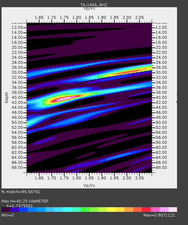
| Estimated Moho Depth: |
40.25 km |
| Estimated Crust Vp/Vs: |
1.75 |
| Assumed Crust Vp: |
6.498 km/s |
| Estimated Crust Vs: |
3.718 km/s |
| Estimated Crust Poisson's Ratio: |
0.26 |
|
| Radial Match: |
95.56761 % |
| Radial Bump: |
229 |
| Transverse Match: |
84.03326 % |
| Transverse Bump: |
400 |
| SOD ConfigId: |
7422571 |
| Insert Time: |
2019-04-21 08:13:27.405 +0000 |
| GWidth: |
2.5 |
| Max Bumps: |
400 |
| Tol: |
0.001 |
|

Signal To Noise
| Channel | StoN | STA | LTA |
| TA:O48A: :BHZ:20151111T02:05:21.600015Z | 10.369109 | 1.8550936E-6 | 1.7890578E-7 |
| TA:O48A: :BHN:20151111T02:05:21.600015Z | 4.843869 | 9.248477E-7 | 1.9093159E-7 |
| TA:O48A: :BHE:20151111T02:05:21.600015Z | 0.51867425 | 1.1315234E-7 | 2.1815684E-7 |
| Arrivals |
| Ps | 4.8 SECOND |
| PpPs | 16 SECOND |
| PsPs/PpSs | 21 SECOND |


