You are here: Home > Network List > IC - New China Digital Seismograph Network Stations List
> Station ENH Enshi, Hubei Province, China > Earthquake Result Viewer
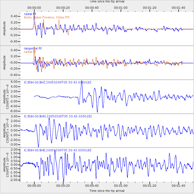
ENH Enshi, Hubei Province, China - Earthquake Result Viewer

| Earthquake location: |
North Of Severnaya Zemlya |
| Earthquake latitude/longitude: |
84.9/99.4 |
| Earthquake time(UTC): |
2005/03/06 (065) 05:21:43 GMT |
| Earthquake Depth: |
10 km |
| Earthquake Magnitude: |
6.1 MB, 6.1 MS, 6.2 MW, 6.2 MW |
| Earthquake Catalog/Contributor: |
WHDF/NEIC |
|
| Network: |
IC New China Digital Seismograph Network |
| Station: |
ENH Enshi, Hubei Province, China |
| Lat/Lon: |
30.27 N/109.49 E |
| Elevation: |
487 m |
|
| Distance: |
54.9 deg |
| Az: |
169.317 deg |
| Baz: |
358.912 deg |
| Ray Param: |
0.06515571 |
| Estimated Moho Depth: |
10.5 km |
| Estimated Crust Vp/Vs: |
1.60 |
| Assumed Crust Vp: |
6.083 km/s |
| Estimated Crust Vs: |
3.802 km/s |
| Estimated Crust Poisson's Ratio: |
0.18 |
|
| Radial Match: |
92.68085 % |
| Radial Bump: |
400 |
| Transverse Match: |
87.81914 % |
| Transverse Bump: |
400 |
| SOD ConfigId: |
2455 |
| Insert Time: |
2010-03-04 21:50:12.038 +0000 |
| GWidth: |
2.5 |
| Max Bumps: |
400 |
| Tol: |
0.001 |
|
Signal To Noise
| Channel | StoN | STA | LTA |
| IC:ENH:00:BHN:20050306T05:30:43.036018Z | 7.9656434 | 1.4283443E-6 | 1.793131E-7 |
| IC:ENH:00:BHE:20050306T05:30:43.036018Z | 2.8421965 | 6.47228E-7 | 2.2772106E-7 |
| IC:ENH:00:BHZ:20050306T05:30:43.036018Z | 9.690586 | 2.6997516E-6 | 2.785953E-7 |
| Arrivals |
| Ps | 1.1 SECOND |
| PpPs | 4.3 SECOND |
| PsPs/PpSs | 5.4 SECOND |


