You are here: Home > Network List > WY - Yellowstone Wyoming Seismic Network Stations List
> Station YHH Holmes Hill, YNP, WY, USA > Earthquake Result Viewer
YHH Holmes Hill, YNP, WY, USA - Earthquake Result Viewer
| Earthquake location: |
Off Coast Of Central Chile |
| Earthquake latitude/longitude: |
-29.4/-72.1 |
| Earthquake time(UTC): |
2015/11/11 (315) 01:54:37 GMT |
| Earthquake Depth: |
10 km |
| Earthquake Magnitude: |
6.9 MWW, 6.6 MI |
| Earthquake Catalog/Contributor: |
NEIC PDE/NEIC COMCAT |
|
| Network: |
WY Yellowstone Wyoming Seismic Network |
| Station: |
YHH Holmes Hill, YNP, WY, USA |
| Lat/Lon: |
44.79 N/110.85 W |
| Elevation: |
2717 m |
|
| Distance: |
81.9 deg |
| Az: |
333.246 deg |
| Baz: |
146.534 deg |
| Ray Param: |
0.047270734 |
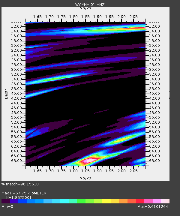
| Estimated Moho Depth: |
67.75 km |
| Estimated Crust Vp/Vs: |
1.87 |
| Assumed Crust Vp: |
6.35 km/s |
| Estimated Crust Vs: |
3.4 km/s |
| Estimated Crust Poisson's Ratio: |
0.30 |
|
| Radial Match: |
96.15638 % |
| Radial Bump: |
350 |
| Transverse Match: |
85.72605 % |
| Transverse Bump: |
400 |
| SOD ConfigId: |
7422571 |
| Insert Time: |
2019-04-21 08:15:54.359 +0000 |
| GWidth: |
2.5 |
| Max Bumps: |
400 |
| Tol: |
0.001 |
|
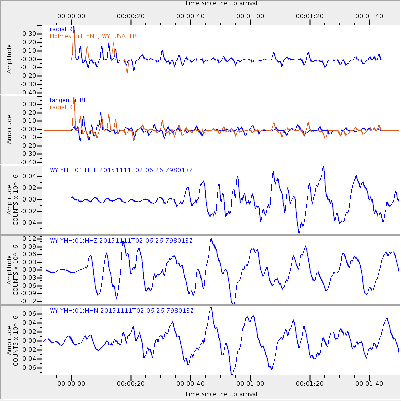
Signal To Noise
| Channel | StoN | STA | LTA |
| WY:YHH:01:HHZ:20151111T02:06:26.798013Z | 1.5114661 | 7.234146E-9 | 4.786178E-9 |
| WY:YHH:01:HHN:20151111T02:06:26.798013Z | 2.4389415 | 6.842706E-9 | 2.8056049E-9 |
| WY:YHH:01:HHE:20151111T02:06:26.798013Z | 1.470101 | 3.1705172E-9 | 2.1566662E-9 |
| Arrivals |
| Ps | 9.5 SECOND |
| PpPs | 30 SECOND |
| PsPs/PpSs | 39 SECOND |


