You are here: Home > Network List > CI - Caltech Regional Seismic Network Stations List
> Station PAS Pasadena, Pasadena, CA, USA > Earthquake Result Viewer
PAS Pasadena, Pasadena, CA, USA - Earthquake Result Viewer
| Earthquake location: |
South Of Fiji Islands |
| Earthquake latitude/longitude: |
-23.6/178.5 |
| Earthquake time(UTC): |
2002/08/19 (231) 11:03:13 GMT |
| Earthquake Depth: |
650 km |
| Earthquake Magnitude: |
5.9 MB |
| Earthquake Catalog/Contributor: |
WHDF/NEIC |
|
| Network: |
CI Caltech Regional Seismic Network |
| Station: |
PAS Pasadena, Pasadena, CA, USA |
| Lat/Lon: |
34.15 N/118.17 W |
| Elevation: |
314 m |
|
| Distance: |
83.1 deg |
| Az: |
48.262 deg |
| Baz: |
235.649 deg |
| Ray Param: |
0.044422813 |
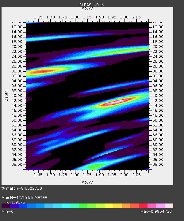
| Estimated Moho Depth: |
42.25 km |
| Estimated Crust Vp/Vs: |
1.97 |
| Assumed Crust Vp: |
6.1 km/s |
| Estimated Crust Vs: |
3.1 km/s |
| Estimated Crust Poisson's Ratio: |
0.33 |
|
| Radial Match: |
84.502716 % |
| Radial Bump: |
309 |
| Transverse Match: |
72.06026 % |
| Transverse Bump: |
400 |
| SOD ConfigId: |
3770 |
| Insert Time: |
2010-02-25 23:55:16.362 +0000 |
| GWidth: |
2.5 |
| Max Bumps: |
400 |
| Tol: |
0.001 |
|

Signal To Noise
| Channel | StoN | STA | LTA |
| CI:PAS: :BHN:20020819T11:14:01.748005Z | 2.43755 | 2.753253E-6 | 1.1295165E-6 |
| CI:PAS: :BHE:20020819T11:14:01.748005Z | 3.5878134 | 4.789971E-6 | 1.335067E-6 |
| CI:PAS: :BHZ:20020819T11:14:01.748005Z | 3.3457198 | 1.0483369E-5 | 3.1333673E-6 |
| Arrivals |
| Ps | 6.8 SECOND |
| PpPs | 20 SECOND |
| PsPs/PpSs | 27 SECOND |


