ENH Enshi, Hubei Province, China - Earthquake Result Viewer
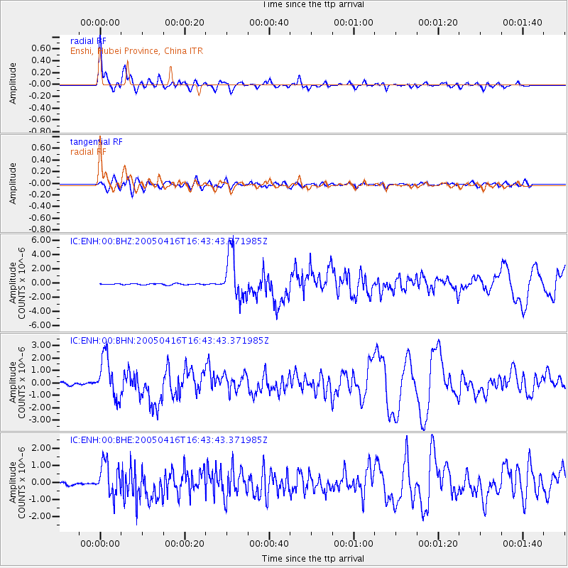
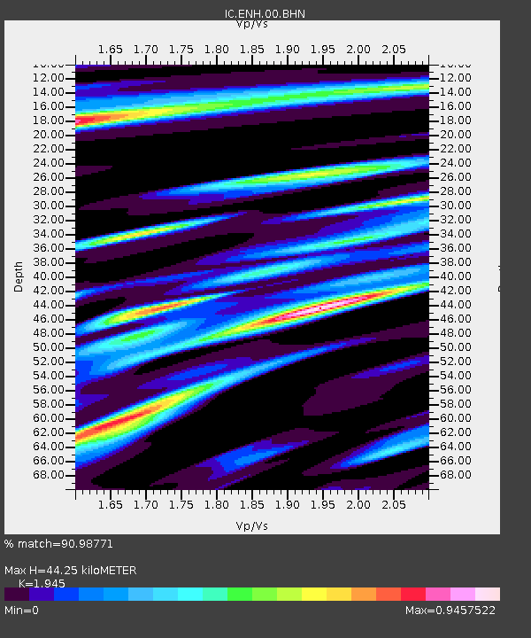
Earthquake location: Northern Sumatra, Indonesia
Earthquake latitude/longitude: 1.8/97.7
Earthquake time(UTC): 2005/04/16 (106) 16:38:03 GMT
Earthquake Depth: 31 km
Earthquake Magnitude: 6.0 MB, 6.2 MS, 6.4 MW, 6.3 MW
Earthquake Catalog/Contributor: WHDF/NEIC
Network: IC New China Digital Seismograph Network
Station: ENH Enshi, Hubei Province, China
Lat/Lon: 30.27 N/109.49 E
Elevation: 487 m
Distance: 30.4 deg
Az: 20.477 deg
Baz: 203.839 deg
Ray Param: 0.07930135
Estimated Moho Depth: 44.25 km
Estimated Crust Vp/Vs: 1.95
Assumed Crust Vp: 6.083 km/s
Estimated Crust Vs: 3.127 km/s
Estimated Crust Poisson's Ratio: 0.32
Radial Match: 90.98771 %
Radial Bump: 382
Transverse Match: 74.96774 %
Transverse Bump: 400
SOD ConfigId: 2459
Insert Time: 2010-03-04 21:51:04.801 +0000
GWidth: 2.5
Max Bumps: 400
Tol: 0.001

Signal To Noise

ChannelStoNSTALTA
IC:ENH:00:BHN:20050416T16:43:43.371985Z20.9184911.6979881E-68.1171635E-8
IC:ENH:00:BHE:20050416T16:43:43.371985Z13.9429389.919786E-77.114559E-8
IC:ENH:00:BHZ:20050416T16:43:43.371985Z38.385513.306448E-68.613793E-8
Arrivals
Ps7.3 SECOND
PpPs20 SECOND
PsPs/PpSs27 SECOND