You are here: Home > Network List > IC - New China Digital Seismograph Network Stations List
> Station ENH Enshi, Hubei Province, China > Earthquake Result Viewer
ENH Enshi, Hubei Province, China - Earthquake Result Viewer
| Earthquake location: |
Tonga Islands |
| Earthquake latitude/longitude: |
-20.5/-174.3 |
| Earthquake time(UTC): |
2005/10/05 (278) 10:07:22 GMT |
| Earthquake Depth: |
15 km |
| Earthquake Magnitude: |
6.0 MB, 5.7 MS, 6.0 MW, 6.0 MW |
| Earthquake Catalog/Contributor: |
WHDF/NEIC |
|
| Network: |
IC New China Digital Seismograph Network |
| Station: |
ENH Enshi, Hubei Province, China |
| Lat/Lon: |
30.27 N/109.49 E |
| Elevation: |
487 m |
|
| Distance: |
89.0 deg |
| Az: |
302.817 deg |
| Baz: |
114.431 deg |
| Ray Param: |
0.042183872 |
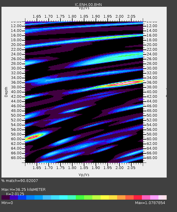
| Estimated Moho Depth: |
36.25 km |
| Estimated Crust Vp/Vs: |
2.01 |
| Assumed Crust Vp: |
6.083 km/s |
| Estimated Crust Vs: |
3.023 km/s |
| Estimated Crust Poisson's Ratio: |
0.34 |
|
| Radial Match: |
90.82007 % |
| Radial Bump: |
400 |
| Transverse Match: |
87.997604 % |
| Transverse Bump: |
400 |
| SOD ConfigId: |
2475 |
| Insert Time: |
2010-03-04 21:51:20.258 +0000 |
| GWidth: |
2.5 |
| Max Bumps: |
400 |
| Tol: |
0.001 |
|
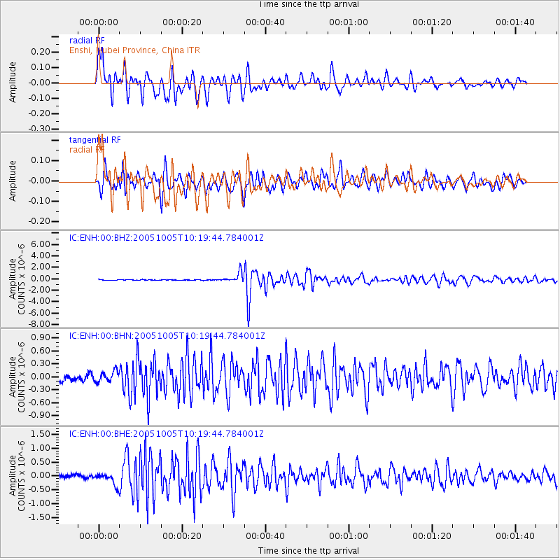
Signal To Noise
| Channel | StoN | STA | LTA |
| IC:ENH:00:BHN:20051005T10:19:44.784001Z | 1.8408803 | 1.2827637E-7 | 6.968208E-8 |
| IC:ENH:00:BHE:20051005T10:19:44.784001Z | 4.747334 | 2.346708E-7 | 4.943212E-8 |
| IC:ENH:00:BHZ:20051005T10:19:44.784001Z | 16.21109 | 8.656862E-7 | 5.3400868E-8 |
| Arrivals |
| Ps | 6.1 SECOND |
| PpPs | 18 SECOND |
| PsPs/PpSs | 24 SECOND |


