You are here: Home > Network List > RV - Regional Alberta Seismic Observatory for Earthquake Studies Network Stations List
> Station MANA Manning, AB > Earthquake Result Viewer
MANA Manning, AB - Earthquake Result Viewer
| Earthquake location: |
Off Coast Of Central Chile |
| Earthquake latitude/longitude: |
-29.5/-72.2 |
| Earthquake time(UTC): |
2015/11/11 (315) 02:46:19 GMT |
| Earthquake Depth: |
10 km |
| Earthquake Magnitude: |
6.9 MWW, 6.8 MWP |
| Earthquake Catalog/Contributor: |
NEIC PDE/NEIC COMCAT |
|
| Network: |
RV Regional Alberta Seismic Observatory for Earthquake Studies Network |
| Station: |
MANA Manning, AB |
| Lat/Lon: |
56.86 N/117.64 W |
| Elevation: |
480 m |
|
| Distance: |
94.2 deg |
| Az: |
336.891 deg |
| Baz: |
141.468 deg |
| Ray Param: |
0.04110035 |
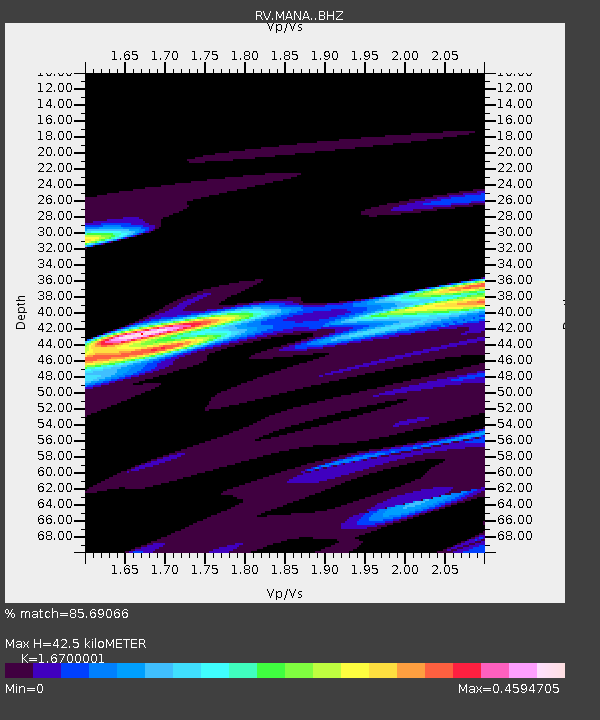
| Estimated Moho Depth: |
42.5 km |
| Estimated Crust Vp/Vs: |
1.67 |
| Assumed Crust Vp: |
6.444 km/s |
| Estimated Crust Vs: |
3.859 km/s |
| Estimated Crust Poisson's Ratio: |
0.22 |
|
| Radial Match: |
85.69066 % |
| Radial Bump: |
400 |
| Transverse Match: |
83.62948 % |
| Transverse Bump: |
400 |
| SOD ConfigId: |
7422571 |
| Insert Time: |
2019-04-21 08:24:01.454 +0000 |
| GWidth: |
2.5 |
| Max Bumps: |
400 |
| Tol: |
0.001 |
|

Signal To Noise
| Channel | StoN | STA | LTA |
| RV:MANA: :BHZ:20151111T02:59:07.47001Z | 2.3701138 | 7.741508E-6 | 3.2663022E-6 |
| RV:MANA: :BHN:20151111T02:59:07.47001Z | 1.0585511 | 3.2469043E-6 | 3.0673098E-6 |
| RV:MANA: :BHE:20151111T02:59:07.47001Z | 0.82798445 | 5.119035E-6 | 6.1825253E-6 |
| Arrivals |
| Ps | 4.5 SECOND |
| PpPs | 17 SECOND |
| PsPs/PpSs | 22 SECOND |


