You are here: Home > Network List > CI - Caltech Regional Seismic Network Stations List
> Station PAS Pasadena, Pasadena, CA, USA > Earthquake Result Viewer
PAS Pasadena, Pasadena, CA, USA - Earthquake Result Viewer
| Earthquake location: |
Central Alaska |
| Earthquake latitude/longitude: |
63.5/-147.9 |
| Earthquake time(UTC): |
2002/10/23 (296) 11:27:19 GMT |
| Earthquake Depth: |
4.2 km |
| Earthquake Magnitude: |
6.0 MB, 6.7 MS, 6.7 MW, 6.7 MW |
| Earthquake Catalog/Contributor: |
WHDF/NEIC |
|
| Network: |
CI Caltech Regional Seismic Network |
| Station: |
PAS Pasadena, Pasadena, CA, USA |
| Lat/Lon: |
34.15 N/118.17 W |
| Elevation: |
314 m |
|
| Distance: |
34.7 deg |
| Az: |
133.697 deg |
| Baz: |
336.99 deg |
| Ray Param: |
0.077628806 |
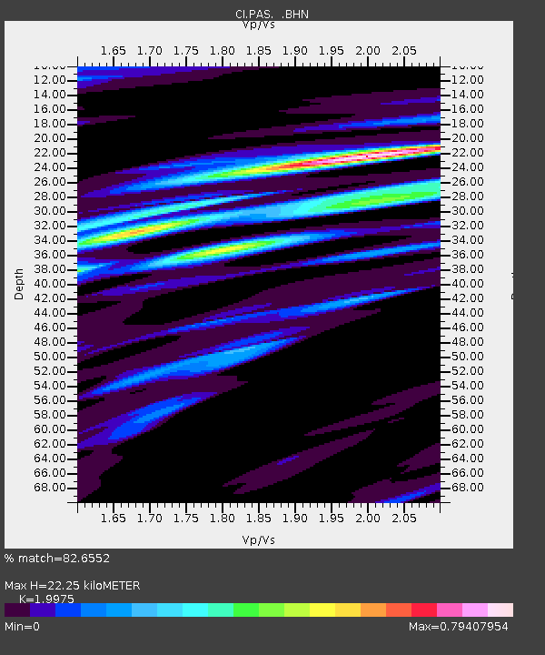
| Estimated Moho Depth: |
22.25 km |
| Estimated Crust Vp/Vs: |
2.00 |
| Assumed Crust Vp: |
6.1 km/s |
| Estimated Crust Vs: |
3.054 km/s |
| Estimated Crust Poisson's Ratio: |
0.33 |
|
| Radial Match: |
82.6552 % |
| Radial Bump: |
400 |
| Transverse Match: |
75.09512 % |
| Transverse Bump: |
400 |
| SOD ConfigId: |
4714 |
| Insert Time: |
2010-02-25 23:55:25.247 +0000 |
| GWidth: |
2.5 |
| Max Bumps: |
400 |
| Tol: |
0.001 |
|

Signal To Noise
| Channel | StoN | STA | LTA |
| CI:PAS: :BHN:20021023T11:33:39.298011Z | 2.364708 | 9.835336E-7 | 4.159218E-7 |
| CI:PAS: :BHE:20021023T11:33:39.298011Z | 1.0605733 | 5.4623035E-7 | 5.150331E-7 |
| CI:PAS: :BHZ:20021023T11:33:39.298011Z | 12.244155 | 1.6785001E-6 | 1.3708582E-7 |
| Arrivals |
| Ps | 3.9 SECOND |
| PpPs | 10 SECOND |
| PsPs/PpSs | 14 SECOND |


