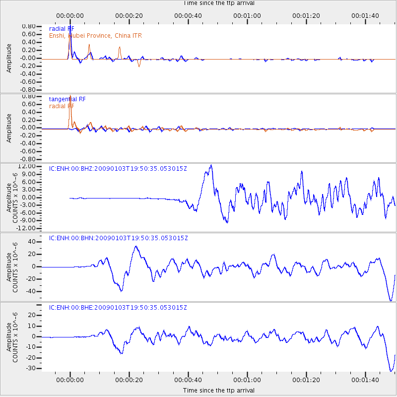
ENH Enshi, Hubei Province, China - Earthquake Result Viewer
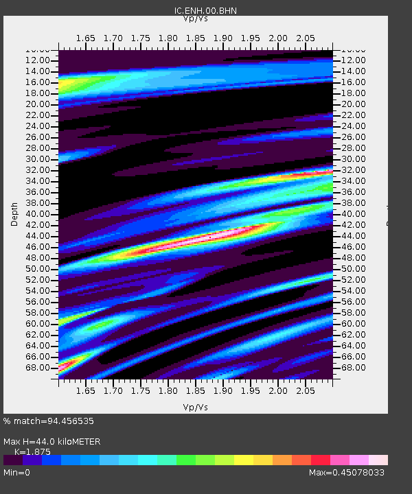
Earthquake location: Irian Jaya Region, Indonesia
Earthquake latitude/longitude: -0.4/132.9
Earthquake time(UTC): 2009/01/03 (003) 19:43:50 GMT
Earthquake Depth: 17 km
Earthquake Magnitude: 6.6 MB, 7.5 MS, 7.6 MW, 7.6 MW
Earthquake Catalog/Contributor: WHDF/NEIC
Network: IC New China Digital Seismograph Network
Station: ENH Enshi, Hubei Province, China
Lat/Lon: 30.27 N/109.49 E
Elevation: 487 m
Distance: 37.8 deg
Az: 325.892 deg
Baz: 139.596 deg
Ray Param: 0.07592392
Estimated Moho Depth: 44.0 km
Estimated Crust Vp/Vs: 1.88
Assumed Crust Vp: 6.083 km/s
Estimated Crust Vs: 3.244 km/s
Estimated Crust Poisson's Ratio: 0.30
Radial Match: 94.456535 %
Radial Bump: 237
Transverse Match: 60.921837 %
Transverse Bump: 400
SOD ConfigId: 2834
Insert Time: 2010-03-04 21:53:24.922 +0000
GWidth: 2.5
Max Bumps: 400
Tol: 0.001

Signal To Noise

ChannelStoNSTALTA
IC:ENH:00:BHN:20090103T19:50:35.053015Z6.00542358.1774374E-71.3616754E-7
IC:ENH:00:BHE:20090103T19:50:35.053015Z4.03514863.6049434E-78.933854E-8
IC:ENH:00:BHZ:20090103T19:50:35.053015Z4.23516373.3440722E-77.895969E-8
Arrivals
Ps6.7 SECOND
PpPs20 SECOND
PsPs/PpSs26 SECOND