You are here: Home > Network List > IC - New China Digital Seismograph Network Stations List
> Station ENH Enshi, Hubei Province, China > Earthquake Result Viewer
ENH Enshi, Hubei Province, China - Earthquake Result Viewer
| Earthquake location: |
Java, Indonesia |
| Earthquake latitude/longitude: |
-5.9/107.7 |
| Earthquake time(UTC): |
2007/08/08 (220) 17:04:57 GMT |
| Earthquake Depth: |
291 km |
| Earthquake Magnitude: |
6.1 MB |
| Earthquake Catalog/Contributor: |
WHDF/NEIC |
|
| Network: |
IC New China Digital Seismograph Network |
| Station: |
ENH Enshi, Hubei Province, China |
| Lat/Lon: |
30.27 N/109.49 E |
| Elevation: |
487 m |
|
| Distance: |
36.0 deg |
| Az: |
2.656 deg |
| Baz: |
183.055 deg |
| Ray Param: |
0.075743 |
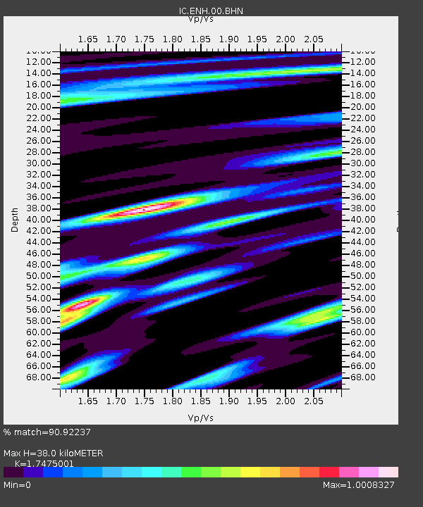
| Estimated Moho Depth: |
38.0 km |
| Estimated Crust Vp/Vs: |
1.75 |
| Assumed Crust Vp: |
6.083 km/s |
| Estimated Crust Vs: |
3.481 km/s |
| Estimated Crust Poisson's Ratio: |
0.26 |
|
| Radial Match: |
90.92237 % |
| Radial Bump: |
400 |
| Transverse Match: |
67.11639 % |
| Transverse Bump: |
400 |
| SOD ConfigId: |
2564 |
| Insert Time: |
2010-03-04 21:53:34.892 +0000 |
| GWidth: |
2.5 |
| Max Bumps: |
400 |
| Tol: |
0.001 |
|

Signal To Noise
| Channel | StoN | STA | LTA |
| IC:ENH:00:BHN:20070808T17:11:01.471012Z | 6.085326 | 3.8007702E-6 | 6.245795E-7 |
| IC:ENH:00:BHE:20070808T17:11:01.471012Z | 2.3968832 | 6.345154E-7 | 2.647252E-7 |
| IC:ENH:00:BHZ:20070808T17:11:01.471012Z | 8.728844 | 7.83617E-6 | 8.9773283E-7 |
| Arrivals |
| Ps | 5.0 SECOND |
| PpPs | 16 SECOND |
| PsPs/PpSs | 21 SECOND |


