You are here: Home > Network List > PF - Volcanologic Network of Piton de Fournaise-OVPF Stations List
> Station HIM cratere Himiltrude > Earthquake Result Viewer
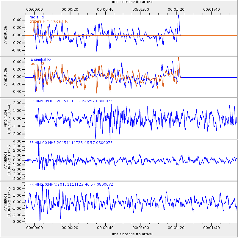
HIM cratere Himiltrude - Earthquake Result Viewer
*The percent match for this event was below the threshold and hence no stack was calculated.
| Earthquake location: |
Banda Sea |
| Earthquake latitude/longitude: |
-7.2/128.9 |
| Earthquake time(UTC): |
2015/11/11 (315) 23:36:18 GMT |
| Earthquake Depth: |
122 km |
| Earthquake Magnitude: |
5.7 MB |
| Earthquake Catalog/Contributor: |
NEIC PDE/NEIC COMCAT |
|
| Network: |
PF Volcanologic Network of Piton de Fournaise-OVPF |
| Station: |
HIM cratere Himiltrude |
| Lat/Lon: |
21.21 S/55.72 E |
| Elevation: |
1958 m |
|
| Distance: |
71.8 deg |
| Az: |
250.116 deg |
| Baz: |
90.844 deg |
| Ray Param: |
$rayparam |
*The percent match for this event was below the threshold and hence was not used in the summary stack. |
|
| Radial Match: |
55.367935 % |
| Radial Bump: |
400 |
| Transverse Match: |
48.672558 % |
| Transverse Bump: |
400 |
| SOD ConfigId: |
7422571 |
| Insert Time: |
2019-04-21 08:42:56.430 +0000 |
| GWidth: |
2.5 |
| Max Bumps: |
400 |
| Tol: |
0.001 |
|
Signal To Noise
| Channel | StoN | STA | LTA |
| PF:HIM:00:HHZ:20151111T23:46:57.080007Z | 3.4497914 | 1.0649871E-6 | 3.0871058E-7 |
| PF:HIM:00:HHN:20151111T23:46:57.080007Z | 2.110224 | 1.1089531E-6 | 5.2551445E-7 |
| PF:HIM:00:HHE:20151111T23:46:57.080007Z | 1.934304 | 8.6963036E-7 | 4.495831E-7 |
| Arrivals |
| Ps | |
| PpPs | |
| PsPs/PpSs | |


