You are here: Home > Network List > IW - Intermountain West Stations List
> Station LOHW Long Hollow, Wyoming, USA > Earthquake Result Viewer
LOHW Long Hollow, Wyoming, USA - Earthquake Result Viewer
| Earthquake location: |
Northern Chile |
| Earthquake latitude/longitude: |
-22.4/-68.3 |
| Earthquake time(UTC): |
2015/06/10 (161) 13:52:08 GMT |
| Earthquake Depth: |
122 km |
| Earthquake Magnitude: |
6.0 MO |
| Earthquake Catalog/Contributor: |
NEIC PDE/NEIC ALERT |
|
| Network: |
IW Intermountain West |
| Station: |
LOHW Long Hollow, Wyoming, USA |
| Lat/Lon: |
43.61 N/110.60 W |
| Elevation: |
2121 m |
|
| Distance: |
76.3 deg |
| Az: |
329.809 deg |
| Baz: |
140.156 deg |
| Ray Param: |
0.050793853 |
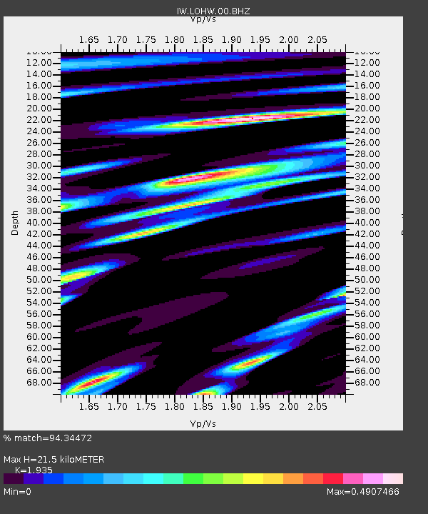
| Estimated Moho Depth: |
21.5 km |
| Estimated Crust Vp/Vs: |
1.93 |
| Assumed Crust Vp: |
6.207 km/s |
| Estimated Crust Vs: |
3.208 km/s |
| Estimated Crust Poisson's Ratio: |
0.32 |
|
| Radial Match: |
94.34472 % |
| Radial Bump: |
355 |
| Transverse Match: |
93.49415 % |
| Transverse Bump: |
400 |
| SOD ConfigId: |
976571 |
| Insert Time: |
2015-06-24 14:07:27.604 +0000 |
| GWidth: |
2.5 |
| Max Bumps: |
400 |
| Tol: |
0.001 |
|

Signal To Noise
| Channel | StoN | STA | LTA |
| IW:LOHW:00:BHZ:20150610T14:03:13.354016Z | 29.953707 | 1.4692478E-6 | 4.9050612E-8 |
| IW:LOHW:00:BH1:20150610T14:03:13.354016Z | 9.456046 | 4.65393E-7 | 4.9216442E-8 |
| IW:LOHW:00:BH2:20150610T14:03:13.354016Z | 11.235667 | 3.6470698E-7 | 3.2459752E-8 |
| Arrivals |
| Ps | 3.3 SECOND |
| PpPs | 9.9 SECOND |
| PsPs/PpSs | 13 SECOND |


