You are here: Home > Network List > AZ - ANZA Regional Network Stations List
> Station SMER AZ.SMER > Earthquake Result Viewer
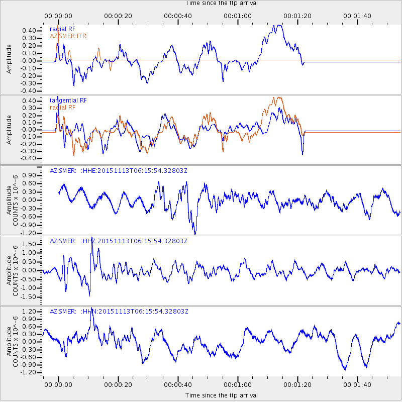
SMER AZ.SMER - Earthquake Result Viewer
*The percent match for this event was below the threshold and hence no stack was calculated.
| Earthquake location: |
Santiago Del Estero Prov., Arg. |
| Earthquake latitude/longitude: |
-29.9/-64.5 |
| Earthquake time(UTC): |
2015/11/13 (317) 06:04:15 GMT |
| Earthquake Depth: |
11 km |
| Earthquake Magnitude: |
5.8 MWP |
| Earthquake Catalog/Contributor: |
NEIC PDE/NEIC COMCAT |
|
| Network: |
AZ ANZA Regional Network |
| Station: |
SMER AZ.SMER |
| Lat/Lon: |
33.46 N/117.17 W |
| Elevation: |
355 m |
|
| Distance: |
80.3 deg |
| Az: |
317.593 deg |
| Baz: |
135.515 deg |
| Ray Param: |
$rayparam |
*The percent match for this event was below the threshold and hence was not used in the summary stack. |
|
| Radial Match: |
42.478424 % |
| Radial Bump: |
400 |
| Transverse Match: |
43.084274 % |
| Transverse Bump: |
400 |
| SOD ConfigId: |
7422571 |
| Insert Time: |
2019-04-21 08:46:02.289 +0000 |
| GWidth: |
2.5 |
| Max Bumps: |
400 |
| Tol: |
0.001 |
|
Signal To Noise
| Channel | StoN | STA | LTA |
| AZ:SMER: :HHZ:20151113T06:15:54.32803Z | 2.9886174 | 5.5057825E-7 | 1.8422507E-7 |
| AZ:SMER: :HHN:20151113T06:15:54.32803Z | 1.4056317 | 3.143724E-7 | 2.2365204E-7 |
| AZ:SMER: :HHE:20151113T06:15:54.32803Z | 1.4279118 | 3.612826E-7 | 2.5301466E-7 |
| Arrivals |
| Ps | |
| PpPs | |
| PsPs/PpSs | |


