You are here: Home > Network List > CI - Caltech Regional Seismic Network Stations List
> Station BAR Barrett, Tecate, CA, USA > Earthquake Result Viewer
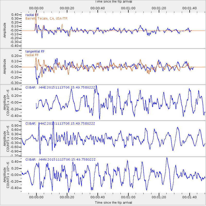
BAR Barrett, Tecate, CA, USA - Earthquake Result Viewer
*The percent match for this event was below the threshold and hence no stack was calculated.
| Earthquake location: |
Santiago Del Estero Prov., Arg. |
| Earthquake latitude/longitude: |
-29.9/-64.5 |
| Earthquake time(UTC): |
2015/11/13 (317) 06:04:15 GMT |
| Earthquake Depth: |
11 km |
| Earthquake Magnitude: |
5.8 MWP |
| Earthquake Catalog/Contributor: |
NEIC PDE/NEIC COMCAT |
|
| Network: |
CI Caltech Regional Seismic Network |
| Station: |
BAR Barrett, Tecate, CA, USA |
| Lat/Lon: |
32.68 N/116.67 W |
| Elevation: |
521 m |
|
| Distance: |
79.5 deg |
| Az: |
317.346 deg |
| Baz: |
135.743 deg |
| Ray Param: |
$rayparam |
*The percent match for this event was below the threshold and hence was not used in the summary stack. |
|
| Radial Match: |
31.936903 % |
| Radial Bump: |
400 |
| Transverse Match: |
50.057175 % |
| Transverse Bump: |
400 |
| SOD ConfigId: |
7422571 |
| Insert Time: |
2019-04-21 08:46:25.476 +0000 |
| GWidth: |
2.5 |
| Max Bumps: |
400 |
| Tol: |
0.001 |
|
Signal To Noise
| Channel | StoN | STA | LTA |
| CI:BAR: :HHZ:20151113T06:15:49.758022Z | 2.255906 | 4.17985E-7 | 1.8528475E-7 |
| CI:BAR: :HHN:20151113T06:15:49.758022Z | 2.3642902 | 2.9175902E-7 | 1.2340237E-7 |
| CI:BAR: :HHE:20151113T06:15:49.758022Z | 1.1892257 | 1.6494954E-7 | 1.3870331E-7 |
| Arrivals |
| Ps | |
| PpPs | |
| PsPs/PpSs | |


