You are here: Home > Network List > CI - Caltech Regional Seismic Network Stations List
> Station MPP McPhearson Peak > Earthquake Result Viewer
MPP McPhearson Peak - Earthquake Result Viewer
*The percent match for this event was below the threshold and hence no stack was calculated.
| Earthquake location: |
Santiago Del Estero Prov., Arg. |
| Earthquake latitude/longitude: |
-29.9/-64.5 |
| Earthquake time(UTC): |
2015/11/13 (317) 06:04:15 GMT |
| Earthquake Depth: |
11 km |
| Earthquake Magnitude: |
5.8 MWP |
| Earthquake Catalog/Contributor: |
NEIC PDE/NEIC COMCAT |
|
| Network: |
CI Caltech Regional Seismic Network |
| Station: |
MPP McPhearson Peak |
| Lat/Lon: |
34.89 N/119.81 W |
| Elevation: |
1739 m |
|
| Distance: |
82.9 deg |
| Az: |
317.059 deg |
| Baz: |
133.959 deg |
| Ray Param: |
$rayparam |
*The percent match for this event was below the threshold and hence was not used in the summary stack. |
|
| Radial Match: |
56.691734 % |
| Radial Bump: |
400 |
| Transverse Match: |
65.30497 % |
| Transverse Bump: |
400 |
| SOD ConfigId: |
7422571 |
| Insert Time: |
2019-04-21 08:46:45.521 +0000 |
| GWidth: |
2.5 |
| Max Bumps: |
400 |
| Tol: |
0.001 |
|
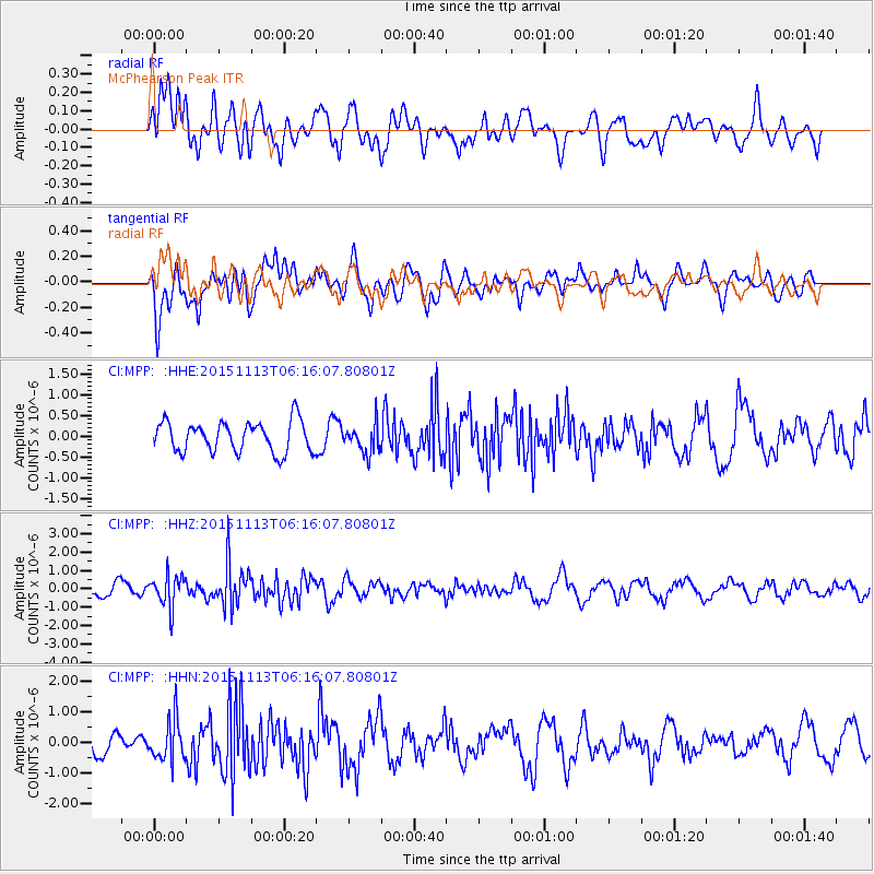
Signal To Noise
| Channel | StoN | STA | LTA |
| CI:MPP: :HHZ:20151113T06:16:07.80801Z | 2.2599657 | 8.66232E-7 | 3.832943E-7 |
| CI:MPP: :HHN:20151113T06:16:07.80801Z | 1.5273488 | 6.7783105E-7 | 4.4379587E-7 |
| CI:MPP: :HHE:20151113T06:16:07.80801Z | 0.93566555 | 3.4560293E-7 | 3.6936586E-7 |
| Arrivals |
| Ps | |
| PpPs | |
| PsPs/PpSs | |


