You are here: Home > Network List > N4 - Central and EAstern US Network Stations List
> Station T42B Van Buren, MO, USA > Earthquake Result Viewer
T42B Van Buren, MO, USA - Earthquake Result Viewer
| Earthquake location: |
Santiago Del Estero Prov., Arg. |
| Earthquake latitude/longitude: |
-29.9/-64.5 |
| Earthquake time(UTC): |
2015/11/13 (317) 06:04:15 GMT |
| Earthquake Depth: |
11 km |
| Earthquake Magnitude: |
5.8 MWP |
| Earthquake Catalog/Contributor: |
NEIC PDE/NEIC COMCAT |
|
| Network: |
N4 Central and EAstern US Network |
| Station: |
T42B Van Buren, MO, USA |
| Lat/Lon: |
37.03 N/91.09 W |
| Elevation: |
165 m |
|
| Distance: |
71.1 deg |
| Az: |
337.745 deg |
| Baz: |
155.727 deg |
| Ray Param: |
0.05456413 |
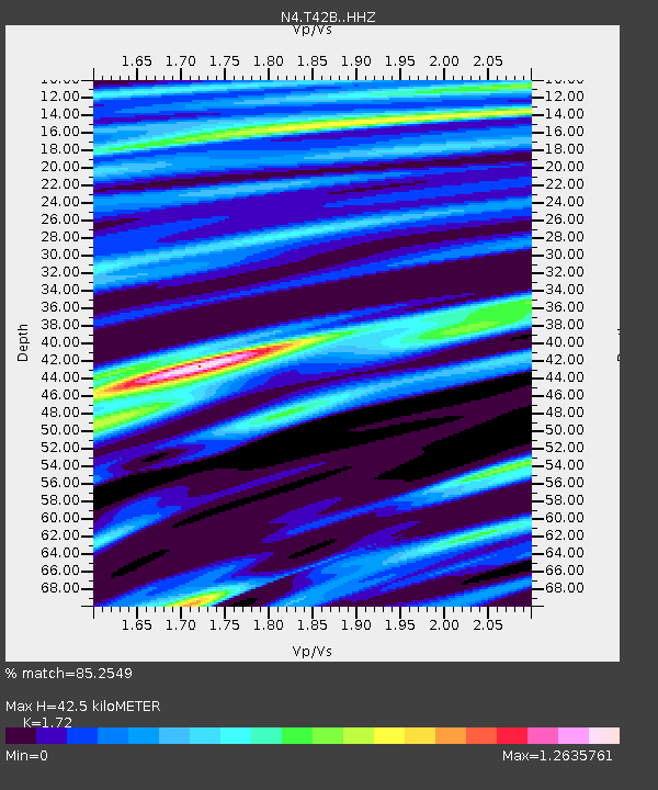
| Estimated Moho Depth: |
42.5 km |
| Estimated Crust Vp/Vs: |
1.72 |
| Assumed Crust Vp: |
6.53 km/s |
| Estimated Crust Vs: |
3.797 km/s |
| Estimated Crust Poisson's Ratio: |
0.24 |
|
| Radial Match: |
85.2549 % |
| Radial Bump: |
400 |
| Transverse Match: |
65.80712 % |
| Transverse Bump: |
400 |
| SOD ConfigId: |
7422571 |
| Insert Time: |
2019-04-21 08:49:36.722 +0000 |
| GWidth: |
2.5 |
| Max Bumps: |
400 |
| Tol: |
0.001 |
|

Signal To Noise
| Channel | StoN | STA | LTA |
| N4:T42B: :HHZ:20151113T06:15:01.620022Z | 2.2420707 | 8.588693E-7 | 3.830697E-7 |
| N4:T42B: :HHN:20151113T06:15:01.620022Z | 1.9067798 | 4.3626235E-7 | 2.2879536E-7 |
| N4:T42B: :HHE:20151113T06:15:01.620022Z | 0.87113285 | 3.805468E-7 | 4.368413E-7 |
| Arrivals |
| Ps | 4.9 SECOND |
| PpPs | 17 SECOND |
| PsPs/PpSs | 22 SECOND |


