You are here: Home > Network List > N4 - Central and EAstern US Network Stations List
> Station V53A Sandy Mush, NC, USA > Earthquake Result Viewer
V53A Sandy Mush, NC, USA - Earthquake Result Viewer
| Earthquake location: |
Santiago Del Estero Prov., Arg. |
| Earthquake latitude/longitude: |
-29.9/-64.5 |
| Earthquake time(UTC): |
2015/11/13 (317) 06:04:15 GMT |
| Earthquake Depth: |
11 km |
| Earthquake Magnitude: |
5.8 MWP |
| Earthquake Catalog/Contributor: |
NEIC PDE/NEIC COMCAT |
|
| Network: |
N4 Central and EAstern US Network |
| Station: |
V53A Sandy Mush, NC, USA |
| Lat/Lon: |
35.67 N/82.81 W |
| Elevation: |
681 m |
|
| Distance: |
67.4 deg |
| Az: |
343.915 deg |
| Baz: |
162.809 deg |
| Ray Param: |
0.0569596 |
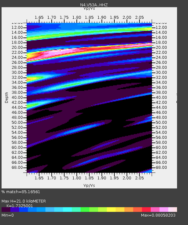
| Estimated Moho Depth: |
21.0 km |
| Estimated Crust Vp/Vs: |
1.73 |
| Assumed Crust Vp: |
6.35 km/s |
| Estimated Crust Vs: |
3.665 km/s |
| Estimated Crust Poisson's Ratio: |
0.25 |
|
| Radial Match: |
85.16561 % |
| Radial Bump: |
355 |
| Transverse Match: |
58.298073 % |
| Transverse Bump: |
400 |
| SOD ConfigId: |
7422571 |
| Insert Time: |
2019-04-21 08:49:47.031 +0000 |
| GWidth: |
2.5 |
| Max Bumps: |
400 |
| Tol: |
0.001 |
|

Signal To Noise
| Channel | StoN | STA | LTA |
| N4:V53A: :HHZ:20151113T06:14:39.14999Z | 2.291595 | 1.2762758E-6 | 5.569378E-7 |
| N4:V53A: :HHN:20151113T06:14:39.14999Z | 1.490894 | 6.1625093E-7 | 4.1334323E-7 |
| N4:V53A: :HHE:20151113T06:14:39.14999Z | 1.4567084 | 7.3389003E-7 | 5.038002E-7 |
| Arrivals |
| Ps | 2.5 SECOND |
| PpPs | 8.7 SECOND |
| PsPs/PpSs | 11 SECOND |


