You are here: Home > Network List > IC - New China Digital Seismograph Network Stations List
> Station ENH Enshi, Hubei Province, China > Earthquake Result Viewer
ENH Enshi, Hubei Province, China - Earthquake Result Viewer
| Earthquake location: |
Seram, Indonesia |
| Earthquake latitude/longitude: |
-3.7/127.3 |
| Earthquake time(UTC): |
2007/01/11 (011) 14:31:20 GMT |
| Earthquake Depth: |
13 km |
| Earthquake Magnitude: |
5.8 MB, 5.8 MS, 6.0 MW, 5.9 MW |
| Earthquake Catalog/Contributor: |
WHDF/NEIC |
|
| Network: |
IC New China Digital Seismograph Network |
| Station: |
ENH Enshi, Hubei Province, China |
| Lat/Lon: |
30.27 N/109.49 E |
| Elevation: |
487 m |
|
| Distance: |
37.8 deg |
| Az: |
334.435 deg |
| Baz: |
150.145 deg |
| Ray Param: |
0.07593152 |
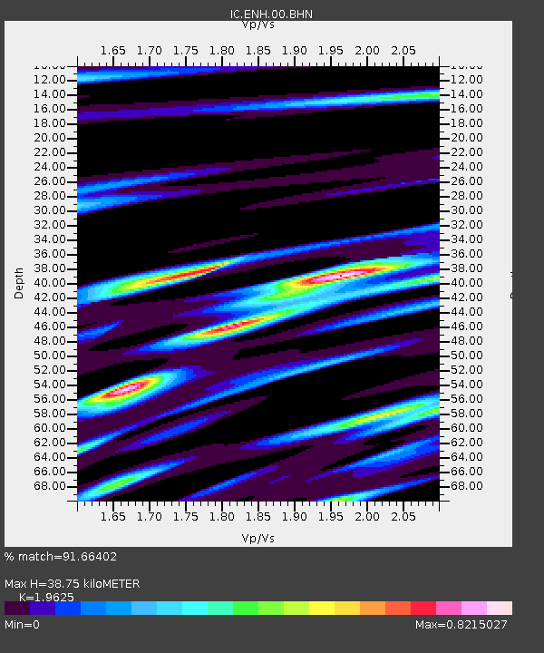
| Estimated Moho Depth: |
38.75 km |
| Estimated Crust Vp/Vs: |
1.96 |
| Assumed Crust Vp: |
6.083 km/s |
| Estimated Crust Vs: |
3.1 km/s |
| Estimated Crust Poisson's Ratio: |
0.32 |
|
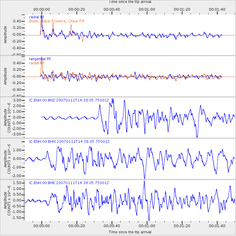
| Radial Match: |
91.66402 % |
| Radial Bump: |
400 |
| Transverse Match: |
76.03987 % |
| Transverse Bump: |
400 |
| SOD ConfigId: |
2564 |
| Insert Time: |
2010-03-04 21:55:21.363 +0000 |
| GWidth: |
2.5 |
| Max Bumps: |
400 |
| Tol: |
0.001 |
|
Signal To Noise
| Channel | StoN | STA | LTA |
| IC:ENH:00:BHN:20070111T14:38:05.75001Z | 3.3982692 | 3.471787E-7 | 1.0216339E-7 |
| IC:ENH:00:BHE:20070111T14:38:05.75001Z | 0.96395075 | 1.6032759E-7 | 1.6632342E-7 |
| IC:ENH:00:BHZ:20070111T14:38:05.75001Z | 5.106288 | 8.377308E-7 | 1.6405866E-7 |
| Arrivals |
| Ps | 6.5 SECOND |
| PpPs | 18 SECOND |
| PsPs/PpSs | 24 SECOND |


