You are here: Home > Network List > IC - New China Digital Seismograph Network Stations List
> Station ENH Enshi, Hubei Province, China > Earthquake Result Viewer
ENH Enshi, Hubei Province, China - Earthquake Result Viewer
| Earthquake location: |
Samoa Islands Region |
| Earthquake latitude/longitude: |
-15.2/-172.6 |
| Earthquake time(UTC): |
2009/08/30 (242) 14:51:32 GMT |
| Earthquake Depth: |
11 km |
| Earthquake Magnitude: |
6.4 MB, 6.3 MS, 6.6 MW, 6.6 MW |
| Earthquake Catalog/Contributor: |
WHDF/NEIC |
|
| Network: |
IC New China Digital Seismograph Network |
| Station: |
ENH Enshi, Hubei Province, China |
| Lat/Lon: |
30.27 N/109.49 E |
| Elevation: |
487 m |
|
| Distance: |
87.5 deg |
| Az: |
302.132 deg |
| Baz: |
109.099 deg |
| Ray Param: |
0.043278705 |
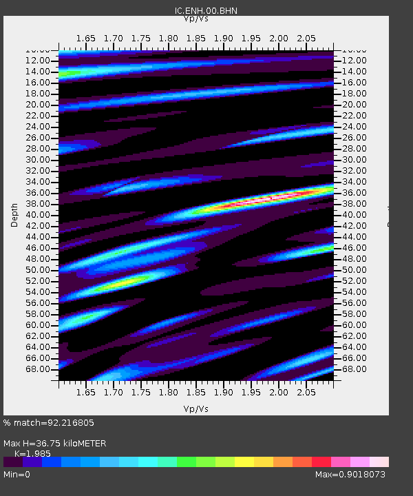
| Estimated Moho Depth: |
36.75 km |
| Estimated Crust Vp/Vs: |
1.99 |
| Assumed Crust Vp: |
6.083 km/s |
| Estimated Crust Vs: |
3.064 km/s |
| Estimated Crust Poisson's Ratio: |
0.33 |
|
| Radial Match: |
92.216805 % |
| Radial Bump: |
400 |
| Transverse Match: |
93.25351 % |
| Transverse Bump: |
396 |
| SOD ConfigId: |
2622 |
| Insert Time: |
2010-03-04 21:55:43.656 +0000 |
| GWidth: |
2.5 |
| Max Bumps: |
400 |
| Tol: |
0.001 |
|

Signal To Noise
| Channel | StoN | STA | LTA |
| IC:ENH:00:BHN:20090830T15:03:48.983994Z | 14.242387 | 1.24022E-6 | 8.70795E-8 |
| IC:ENH:00:BHE:20090830T15:03:48.983994Z | 1.4096704 | 8.432108E-8 | 5.9816166E-8 |
| IC:ENH:00:BHZ:20090830T15:03:48.983994Z | 4.6145535 | 2.4759203E-7 | 5.3654603E-8 |
| Arrivals |
| Ps | 6.1 SECOND |
| PpPs | 18 SECOND |
| PsPs/PpSs | 24 SECOND |


