You are here: Home > Network List > IC - New China Digital Seismograph Network Stations List
> Station ENH Enshi, Hubei Province, China > Earthquake Result Viewer
ENH Enshi, Hubei Province, China - Earthquake Result Viewer
| Earthquake location: |
Southern Sumatra, Indonesia |
| Earthquake latitude/longitude: |
-0.7/99.9 |
| Earthquake time(UTC): |
2009/09/30 (273) 10:16:09 GMT |
| Earthquake Depth: |
81 km |
| Earthquake Magnitude: |
7.1 MB, 7.5 MW, 7.5 MW |
| Earthquake Catalog/Contributor: |
WHDF/NEIC |
|
| Network: |
IC New China Digital Seismograph Network |
| Station: |
ENH Enshi, Hubei Province, China |
| Lat/Lon: |
30.27 N/109.49 E |
| Elevation: |
487 m |
|
| Distance: |
32.2 deg |
| Az: |
15.762 deg |
| Baz: |
198.299 deg |
| Ray Param: |
0.07857136 |
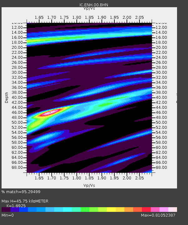
| Estimated Moho Depth: |
45.75 km |
| Estimated Crust Vp/Vs: |
1.69 |
| Assumed Crust Vp: |
6.083 km/s |
| Estimated Crust Vs: |
3.594 km/s |
| Estimated Crust Poisson's Ratio: |
0.23 |
|
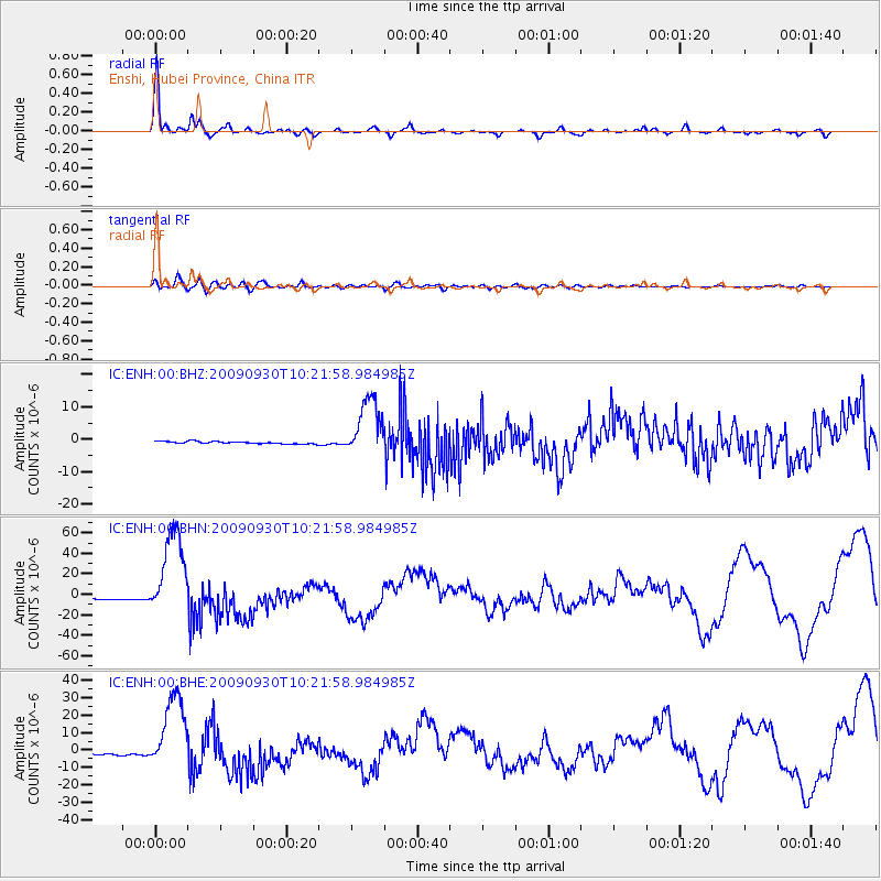
| Radial Match: |
95.29499 % |
| Radial Bump: |
321 |
| Transverse Match: |
67.49725 % |
| Transverse Bump: |
400 |
| SOD ConfigId: |
2622 |
| Insert Time: |
2010-03-04 21:55:48.664 +0000 |
| GWidth: |
2.5 |
| Max Bumps: |
400 |
| Tol: |
0.001 |
|
Signal To Noise
| Channel | StoN | STA | LTA |
| IC:ENH:00:BHN:20090930T10:21:58.984985Z | 42.5552 | 4.3148942E-5 | 1.0139522E-6 |
| IC:ENH:00:BHE:20090930T10:21:58.984985Z | 32.900307 | 2.2068181E-5 | 6.7075916E-7 |
| IC:ENH:00:BHZ:20090930T10:21:58.984985Z | 25.298695 | 9.14384E-6 | 3.6143524E-7 |
| Arrivals |
| Ps | 5.6 SECOND |
| PpPs | 19 SECOND |
| PsPs/PpSs | 24 SECOND |


