You are here: Home > Network List > IU - Global Seismograph Network (GSN - IRIS/USGS) Stations List
> Station CTAO Charters Towers, Australia > Earthquake Result Viewer
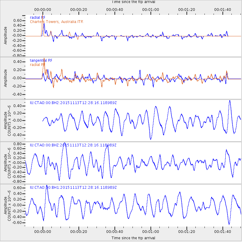
CTAO Charters Towers, Australia - Earthquake Result Viewer
*The percent match for this event was below the threshold and hence no stack was calculated.
| Earthquake location: |
Mariana Islands Region |
| Earthquake latitude/longitude: |
17.3/147.2 |
| Earthquake time(UTC): |
2015/11/13 (317) 12:21:37 GMT |
| Earthquake Depth: |
16 km |
| Earthquake Magnitude: |
5.4 mwb |
| Earthquake Catalog/Contributor: |
NEIC PDE/us |
|
| Network: |
IU Global Seismograph Network (GSN - IRIS/USGS) |
| Station: |
CTAO Charters Towers, Australia |
| Lat/Lon: |
20.09 S/146.25 E |
| Elevation: |
357 m |
|
| Distance: |
37.1 deg |
| Az: |
181.482 deg |
| Baz: |
1.507 deg |
| Ray Param: |
$rayparam |
*The percent match for this event was below the threshold and hence was not used in the summary stack. |
|
| Radial Match: |
58.91546 % |
| Radial Bump: |
318 |
| Transverse Match: |
57.171673 % |
| Transverse Bump: |
365 |
| SOD ConfigId: |
7422571 |
| Insert Time: |
2019-04-21 08:58:17.471 +0000 |
| GWidth: |
2.5 |
| Max Bumps: |
400 |
| Tol: |
0.001 |
|
Signal To Noise
| Channel | StoN | STA | LTA |
| IU:CTAO:00:BHZ:20151113T12:28:16.118989Z | 0.9599246 | 2.3337073E-7 | 2.431136E-7 |
| IU:CTAO:00:BH1:20151113T12:28:16.118989Z | 1.9795805 | 3.6526257E-7 | 1.8451514E-7 |
| IU:CTAO:00:BH2:20151113T12:28:16.118989Z | 1.0902236 | 1.4375176E-7 | 1.3185532E-7 |
| Arrivals |
| Ps | |
| PpPs | |
| PsPs/PpSs | |


