You are here: Home > Network List > TA - USArray Transportable Network (new EarthScope stations) Stations List
> Station MDND Maddock, ND, USA > Earthquake Result Viewer
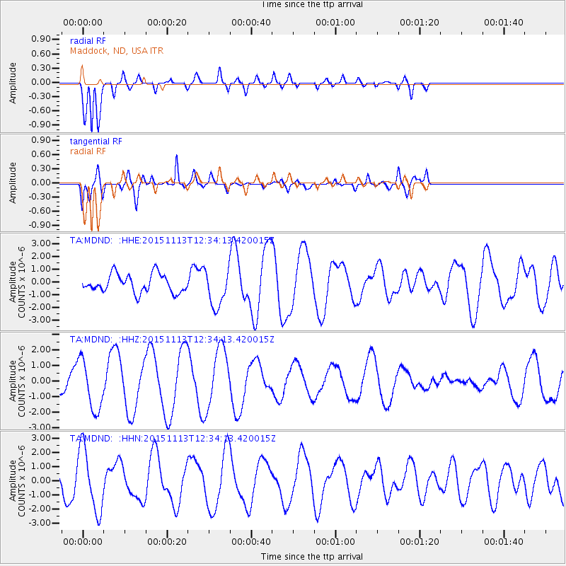
MDND Maddock, ND, USA - Earthquake Result Viewer
*The percent match for this event was below the threshold and hence no stack was calculated.
| Earthquake location: |
Mariana Islands Region |
| Earthquake latitude/longitude: |
17.3/147.2 |
| Earthquake time(UTC): |
2015/11/13 (317) 12:21:37 GMT |
| Earthquake Depth: |
16 km |
| Earthquake Magnitude: |
5.4 mwb |
| Earthquake Catalog/Contributor: |
NEIC PDE/us |
|
| Network: |
TA USArray Transportable Network (new EarthScope stations) |
| Station: |
MDND Maddock, ND, USA |
| Lat/Lon: |
47.85 N/99.60 W |
| Elevation: |
479 m |
|
| Distance: |
92.0 deg |
| Az: |
38.282 deg |
| Baz: |
298.502 deg |
| Ray Param: |
$rayparam |
*The percent match for this event was below the threshold and hence was not used in the summary stack. |
|
| Radial Match: |
87.29937 % |
| Radial Bump: |
400 |
| Transverse Match: |
67.81763 % |
| Transverse Bump: |
400 |
| SOD ConfigId: |
7422571 |
| Insert Time: |
2019-04-21 08:59:47.990 +0000 |
| GWidth: |
2.5 |
| Max Bumps: |
400 |
| Tol: |
0.001 |
|
Signal To Noise
| Channel | StoN | STA | LTA |
| TA:MDND: :HHZ:20151113T12:34:13.420015Z | 1.9651945 | 1.6372436E-6 | 8.331204E-7 |
| TA:MDND: :HHN:20151113T12:34:13.420015Z | 2.2359376 | 2.299508E-6 | 1.0284311E-6 |
| TA:MDND: :HHE:20151113T12:34:13.420015Z | 2.0682304 | 1.473404E-6 | 7.1239845E-7 |
| Arrivals |
| Ps | |
| PpPs | |
| PsPs/PpSs | |


