You are here: Home > Network List > TA - USArray Transportable Network (new EarthScope stations) Stations List
> Station O03E Paynes Creek, CA, USA > Earthquake Result Viewer
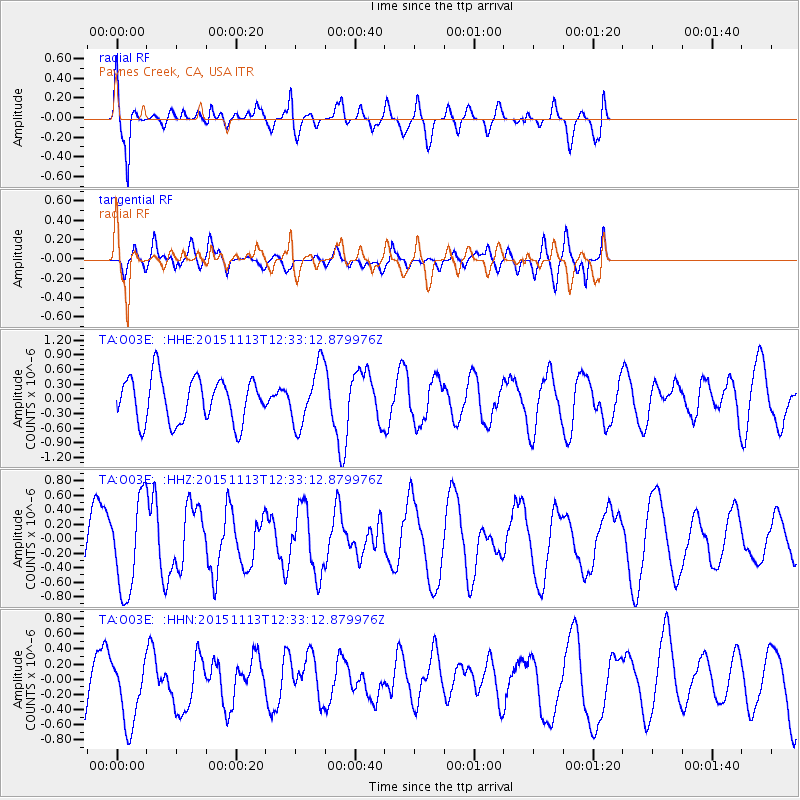
O03E Paynes Creek, CA, USA - Earthquake Result Viewer
*The percent match for this event was below the threshold and hence no stack was calculated.
| Earthquake location: |
Mariana Islands Region |
| Earthquake latitude/longitude: |
17.3/147.2 |
| Earthquake time(UTC): |
2015/11/13 (317) 12:21:37 GMT |
| Earthquake Depth: |
16 km |
| Earthquake Magnitude: |
5.4 mwb |
| Earthquake Catalog/Contributor: |
NEIC PDE/us |
|
| Network: |
TA USArray Transportable Network (new EarthScope stations) |
| Station: |
O03E Paynes Creek, CA, USA |
| Lat/Lon: |
40.29 N/121.80 W |
| Elevation: |
967 m |
|
| Distance: |
79.8 deg |
| Az: |
50.995 deg |
| Baz: |
283.899 deg |
| Ray Param: |
$rayparam |
*The percent match for this event was below the threshold and hence was not used in the summary stack. |
|
| Radial Match: |
62.10973 % |
| Radial Bump: |
400 |
| Transverse Match: |
54.685112 % |
| Transverse Bump: |
400 |
| SOD ConfigId: |
7422571 |
| Insert Time: |
2019-04-21 08:59:50.811 +0000 |
| GWidth: |
2.5 |
| Max Bumps: |
400 |
| Tol: |
0.001 |
|
Signal To Noise
| Channel | StoN | STA | LTA |
| TA:O03E: :HHZ:20151113T12:33:12.879976Z | 2.4374542 | 6.2889376E-7 | 2.5801253E-7 |
| TA:O03E: :HHN:20151113T12:33:12.879976Z | 0.9397491 | 4.858376E-7 | 5.169864E-7 |
| TA:O03E: :HHE:20151113T12:33:12.879976Z | 1.3173897 | 6.013378E-7 | 4.5646158E-7 |
| Arrivals |
| Ps | |
| PpPs | |
| PsPs/PpSs | |


