You are here: Home > Network List > AZ - ANZA Regional Network Stations List
> Station SMER AZ.SMER > Earthquake Result Viewer
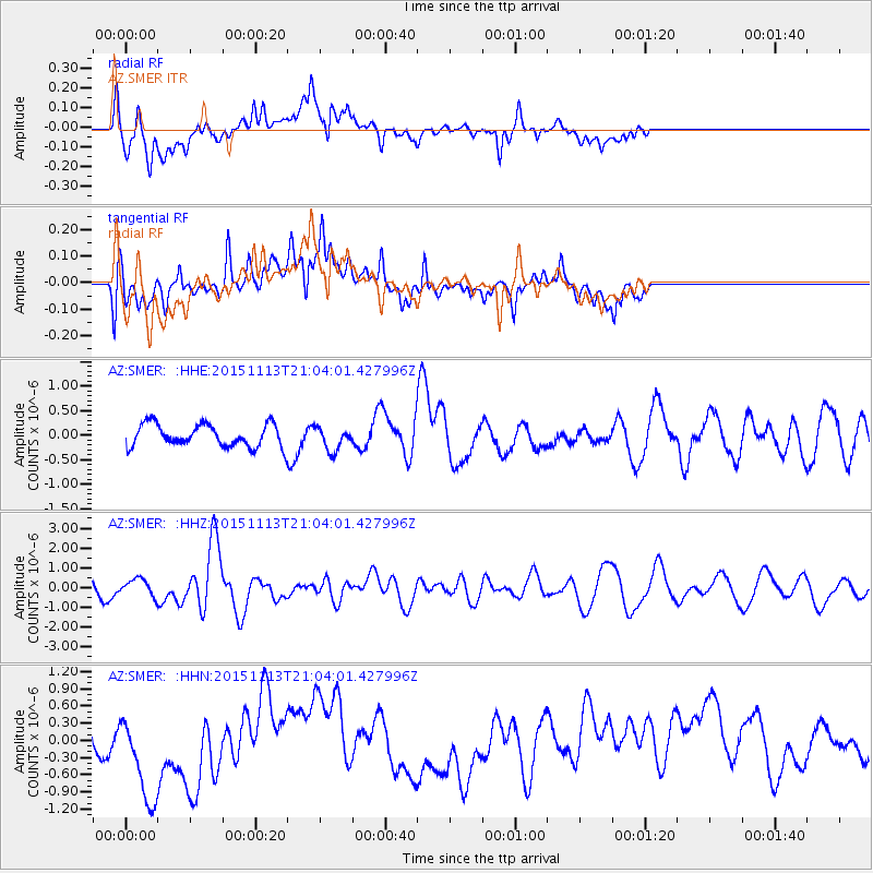
SMER AZ.SMER - Earthquake Result Viewer
*The percent match for this event was below the threshold and hence no stack was calculated.
| Earthquake location: |
Northwest Of Ryukyu Islands |
| Earthquake latitude/longitude: |
31.1/128.8 |
| Earthquake time(UTC): |
2015/11/13 (317) 20:51:32 GMT |
| Earthquake Depth: |
10 km |
| Earthquake Magnitude: |
6.5 MWB |
| Earthquake Catalog/Contributor: |
NEIC PDE/NEIC COMCAT |
|
| Network: |
AZ ANZA Regional Network |
| Station: |
SMER AZ.SMER |
| Lat/Lon: |
33.46 N/117.17 W |
| Elevation: |
355 m |
|
| Distance: |
90.6 deg |
| Az: |
49.789 deg |
| Baz: |
308.378 deg |
| Ray Param: |
$rayparam |
*The percent match for this event was below the threshold and hence was not used in the summary stack. |
|
| Radial Match: |
57.199844 % |
| Radial Bump: |
400 |
| Transverse Match: |
38.445957 % |
| Transverse Bump: |
400 |
| SOD ConfigId: |
7422571 |
| Insert Time: |
2019-04-21 09:02:58.699 +0000 |
| GWidth: |
2.5 |
| Max Bumps: |
400 |
| Tol: |
0.001 |
|
Signal To Noise
| Channel | StoN | STA | LTA |
| AZ:SMER: :HHZ:20151113T21:04:01.427996Z | 1.3560241 | 4.3403307E-7 | 3.2007767E-7 |
| AZ:SMER: :HHN:20151113T21:04:01.427996Z | 5.1023 | 1.022921E-6 | 2.0048232E-7 |
| AZ:SMER: :HHE:20151113T21:04:01.427996Z | 0.90592533 | 2.3822307E-7 | 2.6296104E-7 |
| Arrivals |
| Ps | |
| PpPs | |
| PsPs/PpSs | |


