You are here: Home > Network List > TA - USArray Transportable Network (new EarthScope stations) Stations List
> Station J20K Nowitna River, AK, USA > Earthquake Result Viewer
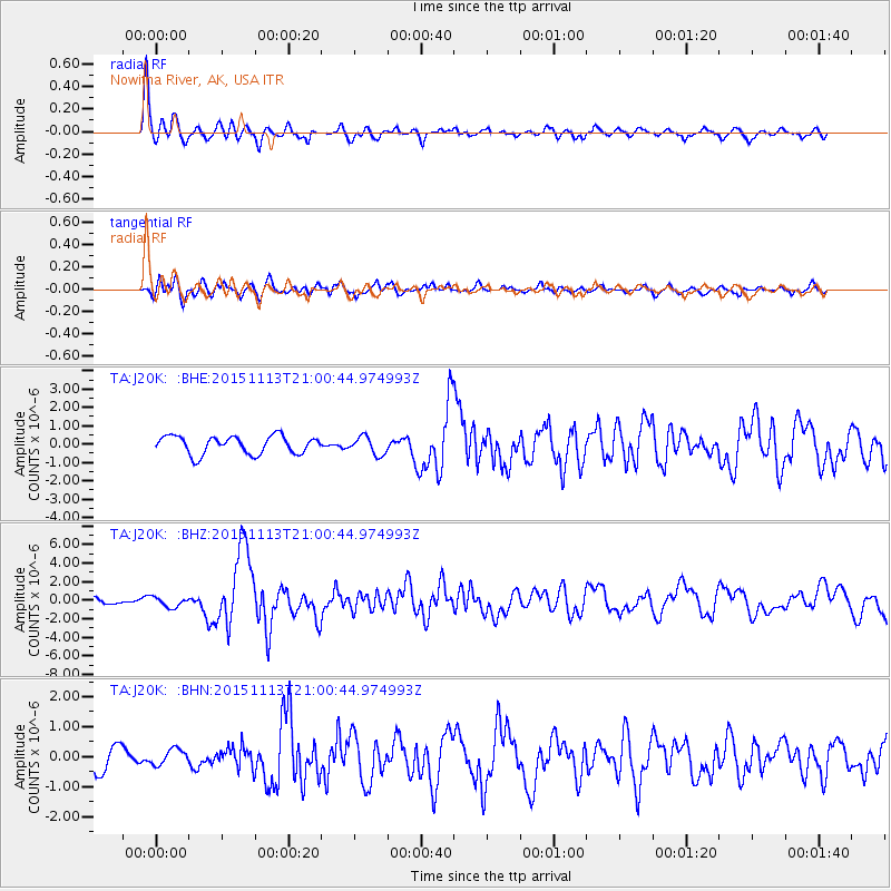
J20K Nowitna River, AK, USA - Earthquake Result Viewer
*The percent match for this event was below the threshold and hence no stack was calculated.
| Earthquake location: |
Northwest Of Ryukyu Islands |
| Earthquake latitude/longitude: |
31.1/128.8 |
| Earthquake time(UTC): |
2015/11/13 (317) 20:51:32 GMT |
| Earthquake Depth: |
10 km |
| Earthquake Magnitude: |
6.5 MWB |
| Earthquake Catalog/Contributor: |
NEIC PDE/NEIC COMCAT |
|
| Network: |
TA USArray Transportable Network (new EarthScope stations) |
| Station: |
J20K Nowitna River, AK, USA |
| Lat/Lon: |
64.18 N/154.15 W |
| Elevation: |
314 m |
|
| Distance: |
56.9 deg |
| Az: |
30.623 deg |
| Baz: |
273.543 deg |
| Ray Param: |
$rayparam |
*The percent match for this event was below the threshold and hence was not used in the summary stack. |
|
| Radial Match: |
86.33292 % |
| Radial Bump: |
400 |
| Transverse Match: |
72.27805 % |
| Transverse Bump: |
400 |
| SOD ConfigId: |
7422571 |
| Insert Time: |
2019-04-21 09:06:58.793 +0000 |
| GWidth: |
2.5 |
| Max Bumps: |
400 |
| Tol: |
0.001 |
|
Signal To Noise
| Channel | StoN | STA | LTA |
| TA:J20K: :BHZ:20151113T21:00:44.974993Z | 1.6598217 | 5.543971E-7 | 3.3401002E-7 |
| TA:J20K: :BHN:20151113T21:00:44.974993Z | 0.7536299 | 2.6542622E-7 | 3.5219702E-7 |
| TA:J20K: :BHE:20151113T21:00:44.974993Z | 1.0221522 | 4.904611E-7 | 4.7983184E-7 |
| Arrivals |
| Ps | |
| PpPs | |
| PsPs/PpSs | |


