You are here: Home > Network List > IU - Global Seismograph Network (GSN - IRIS/USGS) Stations List
> Station PMG Port Moresby, New Guinea > Earthquake Result Viewer
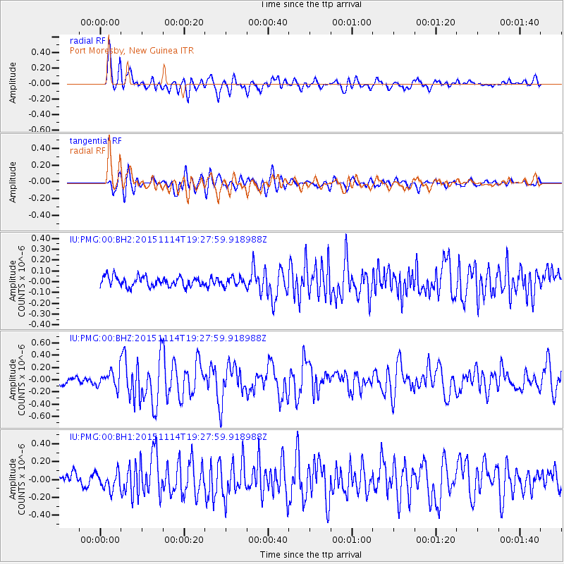
PMG Port Moresby, New Guinea - Earthquake Result Viewer
*The percent match for this event was below the threshold and hence no stack was calculated.
| Earthquake location: |
Northwest Of Ryukyu Islands |
| Earthquake latitude/longitude: |
31.4/129.0 |
| Earthquake time(UTC): |
2015/11/14 (318) 19:20:21 GMT |
| Earthquake Depth: |
26 km |
| Earthquake Magnitude: |
5.7 MB |
| Earthquake Catalog/Contributor: |
NEIC PDE/NEIC ALERT |
|
| Network: |
IU Global Seismograph Network (GSN - IRIS/USGS) |
| Station: |
PMG Port Moresby, New Guinea |
| Lat/Lon: |
9.40 S/147.16 E |
| Elevation: |
90 m |
|
| Distance: |
44.2 deg |
| Az: |
153.756 deg |
| Baz: |
337.475 deg |
| Ray Param: |
$rayparam |
*The percent match for this event was below the threshold and hence was not used in the summary stack. |
|
| Radial Match: |
76.28576 % |
| Radial Bump: |
400 |
| Transverse Match: |
73.02099 % |
| Transverse Bump: |
400 |
| SOD ConfigId: |
7422571 |
| Insert Time: |
2019-04-21 09:12:35.341 +0000 |
| GWidth: |
2.5 |
| Max Bumps: |
400 |
| Tol: |
0.001 |
|
Signal To Noise
| Channel | StoN | STA | LTA |
| IU:PMG:00:BHZ:20151114T19:27:59.918988Z | 2.3292284 | 1.4663709E-7 | 6.2955216E-8 |
| IU:PMG:00:BH1:20151114T19:27:59.918988Z | 1.4754398 | 9.8800655E-8 | 6.696353E-8 |
| IU:PMG:00:BH2:20151114T19:27:59.918988Z | 0.7688677 | 3.5794162E-8 | 4.6554387E-8 |
| Arrivals |
| Ps | |
| PpPs | |
| PsPs/PpSs | |


