You are here: Home > Network List > KN - Kyrgyz Seismic Telemetry Network Stations List
> Station CHM KN.CHM > Earthquake Result Viewer
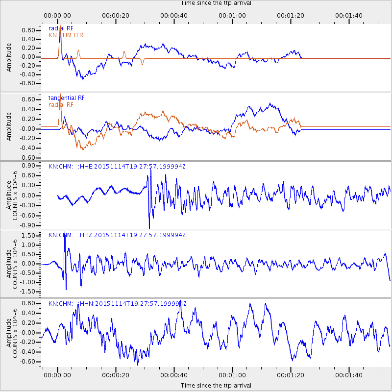
CHM KN.CHM - Earthquake Result Viewer
*The percent match for this event was below the threshold and hence no stack was calculated.
| Earthquake location: |
Northwest Of Ryukyu Islands |
| Earthquake latitude/longitude: |
31.4/129.0 |
| Earthquake time(UTC): |
2015/11/14 (318) 19:20:21 GMT |
| Earthquake Depth: |
26 km |
| Earthquake Magnitude: |
5.7 MB |
| Earthquake Catalog/Contributor: |
NEIC PDE/NEIC ALERT |
|
| Network: |
KN Kyrgyz Seismic Telemetry Network |
| Station: |
CHM KN.CHM |
| Lat/Lon: |
43.00 N/74.75 E |
| Elevation: |
655 m |
|
| Distance: |
44.0 deg |
| Az: |
301.048 deg |
| Baz: |
86.621 deg |
| Ray Param: |
$rayparam |
*The percent match for this event was below the threshold and hence was not used in the summary stack. |
|
| Radial Match: |
52.962017 % |
| Radial Bump: |
400 |
| Transverse Match: |
51.556885 % |
| Transverse Bump: |
400 |
| SOD ConfigId: |
7422571 |
| Insert Time: |
2019-04-21 09:12:44.378 +0000 |
| GWidth: |
2.5 |
| Max Bumps: |
400 |
| Tol: |
0.001 |
|
Signal To Noise
| Channel | StoN | STA | LTA |
| KN:CHM: :HHZ:20151114T19:27:57.199994Z | 4.2936783 | 6.1596114E-7 | 1.4345768E-7 |
| KN:CHM: :HHN:20151114T19:27:57.199994Z | 1.1505768 | 1.4148014E-7 | 1.2296454E-7 |
| KN:CHM: :HHE:20151114T19:27:57.199994Z | 2.6057298 | 3.9496717E-7 | 1.515764E-7 |
| Arrivals |
| Ps | |
| PpPs | |
| PsPs/PpSs | |


