You are here: Home > Network List > KN - Kyrgyz Seismic Telemetry Network Stations List
> Station TKM2 - > Earthquake Result Viewer
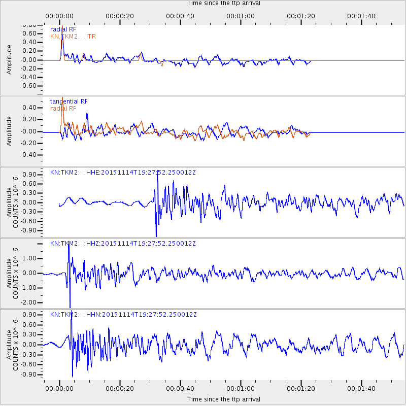
TKM2 - - Earthquake Result Viewer
*The percent match for this event was below the threshold and hence no stack was calculated.
| Earthquake location: |
Northwest Of Ryukyu Islands |
| Earthquake latitude/longitude: |
31.4/129.0 |
| Earthquake time(UTC): |
2015/11/14 (318) 19:20:21 GMT |
| Earthquake Depth: |
26 km |
| Earthquake Magnitude: |
5.7 MB |
| Earthquake Catalog/Contributor: |
NEIC PDE/NEIC ALERT |
|
| Network: |
KN Kyrgyz Seismic Telemetry Network |
| Station: |
TKM2 - |
| Lat/Lon: |
42.92 N/75.60 E |
| Elevation: |
2020 m |
|
| Distance: |
43.4 deg |
| Az: |
300.886 deg |
| Baz: |
87.078 deg |
| Ray Param: |
$rayparam |
*The percent match for this event was below the threshold and hence was not used in the summary stack. |
|
| Radial Match: |
71.99821 % |
| Radial Bump: |
400 |
| Transverse Match: |
66.44203 % |
| Transverse Bump: |
400 |
| SOD ConfigId: |
7422571 |
| Insert Time: |
2019-04-21 09:12:45.696 +0000 |
| GWidth: |
2.5 |
| Max Bumps: |
400 |
| Tol: |
0.001 |
|
Signal To Noise
| Channel | StoN | STA | LTA |
| KN:TKM2: :HHZ:20151114T19:27:52.250012Z | 10.700959 | 7.265915E-7 | 6.789966E-8 |
| KN:TKM2: :HHN:20151114T19:27:52.250012Z | 3.8764844 | 3.0216677E-7 | 7.794866E-8 |
| KN:TKM2: :HHE:20151114T19:27:52.250012Z | 5.5878935 | 3.7746102E-7 | 6.754979E-8 |
| Arrivals |
| Ps | |
| PpPs | |
| PsPs/PpSs | |


