You are here: Home > Network List > CI - Caltech Regional Seismic Network Stations List
> Station PAS Pasadena, Pasadena, CA, USA > Earthquake Result Viewer
PAS Pasadena, Pasadena, CA, USA - Earthquake Result Viewer
| Earthquake location: |
Near Coast Of Guatemala |
| Earthquake latitude/longitude: |
13.6/-90.8 |
| Earthquake time(UTC): |
2003/01/21 (021) 02:46:47 GMT |
| Earthquake Depth: |
24 km |
| Earthquake Magnitude: |
5.5 MB, 6.3 MS, 6.5 MW, 6.3 MW |
| Earthquake Catalog/Contributor: |
WHDF/NEIC |
|
| Network: |
CI Caltech Regional Seismic Network |
| Station: |
PAS Pasadena, Pasadena, CA, USA |
| Lat/Lon: |
34.15 N/118.17 W |
| Elevation: |
314 m |
|
| Distance: |
32.2 deg |
| Az: |
314.181 deg |
| Baz: |
122.786 deg |
| Ray Param: |
0.078745104 |
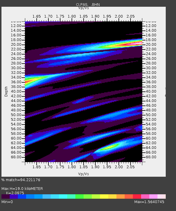
| Estimated Moho Depth: |
19.0 km |
| Estimated Crust Vp/Vs: |
2.10 |
| Assumed Crust Vp: |
6.1 km/s |
| Estimated Crust Vs: |
2.908 km/s |
| Estimated Crust Poisson's Ratio: |
0.35 |
|
| Radial Match: |
94.221176 % |
| Radial Bump: |
380 |
| Transverse Match: |
82.750275 % |
| Transverse Bump: |
400 |
| SOD ConfigId: |
4714 |
| Insert Time: |
2010-02-25 23:56:00.039 +0000 |
| GWidth: |
2.5 |
| Max Bumps: |
400 |
| Tol: |
0.001 |
|

Signal To Noise
| Channel | StoN | STA | LTA |
| CI:PAS: :BHN:20030121T02:52:42.798014Z | 1.8150154 | 4.2946255E-7 | 2.3661649E-7 |
| CI:PAS: :BHE:20030121T02:52:42.798014Z | 1.4260234 | 5.145125E-7 | 3.6080232E-7 |
| CI:PAS: :BHZ:20030121T02:52:42.798014Z | 4.167954 | 1.2233972E-6 | 2.9352464E-7 |
| Arrivals |
| Ps | 3.6 SECOND |
| PpPs | 9.1 SECOND |
| PsPs/PpSs | 13 SECOND |


