You are here: Home > Network List > UU - University of Utah Regional Network Stations List
> Station CCUT Cedar City, UT, USA > Earthquake Result Viewer
CCUT Cedar City, UT, USA - Earthquake Result Viewer
| Earthquake location: |
Northern Chile |
| Earthquake latitude/longitude: |
-22.4/-68.3 |
| Earthquake time(UTC): |
2015/06/10 (161) 13:52:08 GMT |
| Earthquake Depth: |
122 km |
| Earthquake Magnitude: |
6.0 MO |
| Earthquake Catalog/Contributor: |
NEIC PDE/NEIC ALERT |
|
| Network: |
UU University of Utah Regional Network |
| Station: |
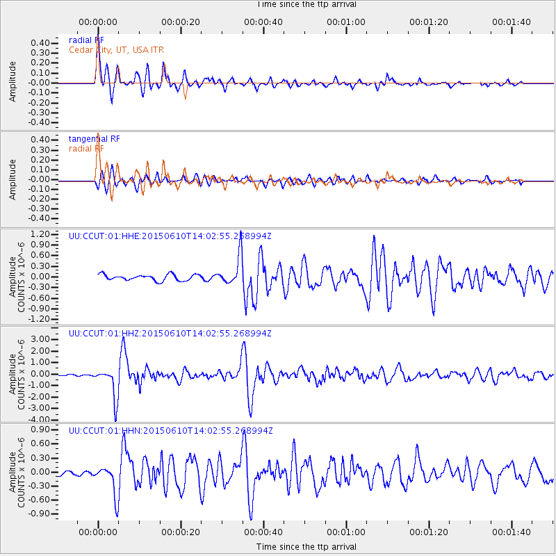
CCUT Cedar City, UT, USA |
| Lat/Lon: |
37.55 N/113.36 W |
| Elevation: |
2127 m |
|
| Distance: |
73.2 deg |
| Az: |
324.019 deg |
| Baz: |
136.839 deg |
| Ray Param: |
0.052886825 |
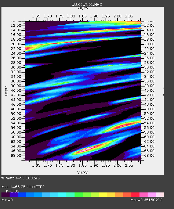
| Estimated Moho Depth: |
65.25 km |
| Estimated Crust Vp/Vs: |
1.86 |
| Assumed Crust Vp: |
6.194 km/s |
| Estimated Crust Vs: |
3.33 km/s |
| Estimated Crust Poisson's Ratio: |
0.30 |
|
| Radial Match: |
93.163246 % |
| Radial Bump: |
400 |
| Transverse Match: |
82.40559 % |
| Transverse Bump: |
400 |
| SOD ConfigId: |
976571 |
| Insert Time: |
2015-06-24 14:13:32.553 +0000 |
| GWidth: |
2.5 |
| Max Bumps: |
400 |
| Tol: |
0.001 |
|
Signal To Noise
| Channel | StoN | STA | LTA |
| UU:CCUT:01:HHZ:20150610T14:02:55.268994Z | 19.08497 | 1.3955773E-6 | 7.312442E-8 |
| UU:CCUT:01:HHN:20150610T14:02:55.268994Z | 6.237629 | 3.391085E-7 | 5.4364968E-8 |
| UU:CCUT:01:HHE:20150610T14:02:55.268994Z | 5.1673837 | 4.4268018E-7 | 8.566815E-8 |
| Arrivals |
| Ps | 9.3 SECOND |
| PpPs | 29 SECOND |
| PsPs/PpSs | 39 SECOND |


