You are here: Home > Network List > CI - Caltech Regional Seismic Network Stations List
> Station TUQ Turquiose Mountain, Baker, CA, USA > Earthquake Result Viewer
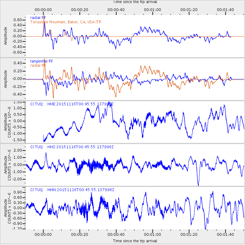
TUQ Turquiose Mountain, Baker, CA, USA - Earthquake Result Viewer
*The percent match for this event was below the threshold and hence no stack was calculated.
| Earthquake location: |
North Of Honduras |
| Earthquake latitude/longitude: |
17.8/-81.8 |
| Earthquake time(UTC): |
2015/11/16 (320) 00:39:33 GMT |
| Earthquake Depth: |
9.1 km |
| Earthquake Magnitude: |
5.8 MWP |
| Earthquake Catalog/Contributor: |
NEIC PDE/NEIC COMCAT |
|
| Network: |
CI Caltech Regional Seismic Network |
| Station: |
TUQ Turquiose Mountain, Baker, CA, USA |
| Lat/Lon: |
35.44 N/115.92 W |
| Elevation: |
1350 m |
|
| Distance: |
34.9 deg |
| Az: |
306.915 deg |
| Baz: |
111.16 deg |
| Ray Param: |
$rayparam |
*The percent match for this event was below the threshold and hence was not used in the summary stack. |
|
| Radial Match: |
47.00876 % |
| Radial Bump: |
400 |
| Transverse Match: |
57.070686 % |
| Transverse Bump: |
400 |
| SOD ConfigId: |
7422571 |
| Insert Time: |
2019-04-21 09:19:52.005 +0000 |
| GWidth: |
2.5 |
| Max Bumps: |
400 |
| Tol: |
0.001 |
|
Signal To Noise
| Channel | StoN | STA | LTA |
| CI:TUQ: :HHZ:20151116T00:45:55.137996Z | 1.9658419 | 6.213897E-7 | 3.1609343E-7 |
| CI:TUQ: :HHN:20151116T00:45:55.137996Z | 0.5885209 | 2.3503026E-7 | 3.9935753E-7 |
| CI:TUQ: :HHE:20151116T00:45:55.137996Z | 2.3578508 | 1.3173105E-6 | 5.586912E-7 |
| Arrivals |
| Ps | |
| PpPs | |
| PsPs/PpSs | |


