You are here: Home > Network List > IC - New China Digital Seismograph Network Stations List
> Station ENH Enshi, Hubei Province, China > Earthquake Result Viewer
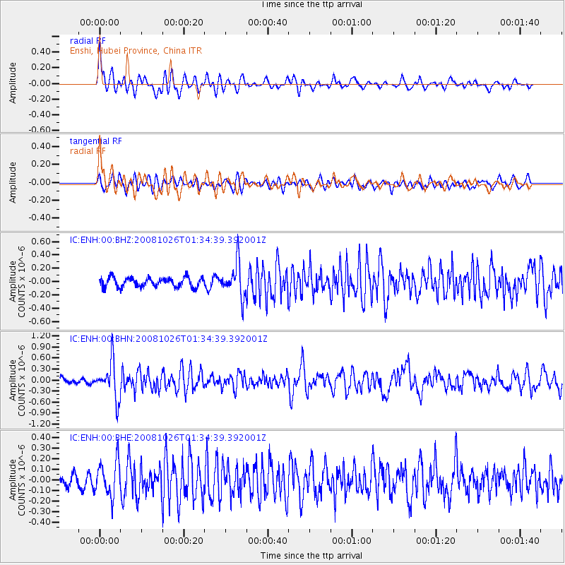
ENH Enshi, Hubei Province, China - Earthquake Result Viewer
*The percent match for this event was below the threshold and hence no stack was calculated.
| Earthquake location: |
Hindu Kush Region, Afghanistan |
| Earthquake latitude/longitude: |
36.5/70.7 |
| Earthquake time(UTC): |
2008/10/26 (300) 01:28:56 GMT |
| Earthquake Depth: |
210 km |
| Earthquake Magnitude: |
5.5 MB, 5.7 MW, 5.7 MW |
| Earthquake Catalog/Contributor: |
WHDF/NEIC |
|
| Network: |
IC New China Digital Seismograph Network |
| Station: |
ENH Enshi, Hubei Province, China |
| Lat/Lon: |
30.27 N/109.49 E |
| Elevation: |
487 m |
|
| Distance: |
32.8 deg |
| Az: |
89.469 deg |
| Baz: |
291.334 deg |
| Ray Param: |
$rayparam |
*The percent match for this event was below the threshold and hence was not used in the summary stack. |
|
| Radial Match: |
72.18218 % |
| Radial Bump: |
400 |
| Transverse Match: |
60.861588 % |
| Transverse Bump: |
400 |
| SOD ConfigId: |
2658 |
| Insert Time: |
2010-03-04 21:58:58.000 +0000 |
| GWidth: |
2.5 |
| Max Bumps: |
400 |
| Tol: |
0.001 |
|
Signal To Noise
| Channel | StoN | STA | LTA |
| IC:ENH:00:BHN:20081026T01:34:39.392001Z | 7.0465846 | 5.18357E-7 | 7.356145E-8 |
| IC:ENH:00:BHE:20081026T01:34:39.392001Z | 2.680002 | 1.6688148E-7 | 6.226916E-8 |
| IC:ENH:00:BHZ:20081026T01:34:39.392001Z | 3.7508225 | 2.633303E-7 | 7.020601E-8 |
| Arrivals |
| Ps | |
| PpPs | |
| PsPs/PpSs | |


