You are here: Home > Network List > TA - USArray Transportable Network (new EarthScope stations) Stations List
> Station MDND Maddock, ND, USA > Earthquake Result Viewer
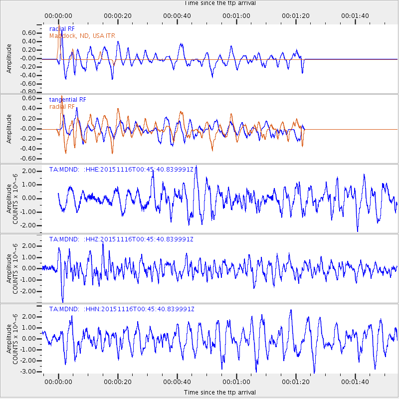
MDND Maddock, ND, USA - Earthquake Result Viewer
*The percent match for this event was below the threshold and hence no stack was calculated.
| Earthquake location: |
North Of Honduras |
| Earthquake latitude/longitude: |
17.8/-81.8 |
| Earthquake time(UTC): |
2015/11/16 (320) 00:39:33 GMT |
| Earthquake Depth: |
9.1 km |
| Earthquake Magnitude: |
5.8 MWP |
| Earthquake Catalog/Contributor: |
NEIC PDE/NEIC COMCAT |
|
| Network: |
TA USArray Transportable Network (new EarthScope stations) |
| Station: |
MDND Maddock, ND, USA |
| Lat/Lon: |
47.85 N/99.60 W |
| Elevation: |
479 m |
|
| Distance: |
33.3 deg |
| Az: |
337.999 deg |
| Baz: |
148.012 deg |
| Ray Param: |
$rayparam |
*The percent match for this event was below the threshold and hence was not used in the summary stack. |
|
| Radial Match: |
67.53655 % |
| Radial Bump: |
400 |
| Transverse Match: |
78.02583 % |
| Transverse Bump: |
399 |
| SOD ConfigId: |
7422571 |
| Insert Time: |
2019-04-21 09:22:39.924 +0000 |
| GWidth: |
2.5 |
| Max Bumps: |
400 |
| Tol: |
0.001 |
|
Signal To Noise
| Channel | StoN | STA | LTA |
| TA:MDND: :HHZ:20151116T00:45:40.839991Z | 5.243681 | 1.2787177E-6 | 2.4385878E-7 |
| TA:MDND: :HHN:20151116T00:45:40.839991Z | 2.055502 | 1.0886112E-6 | 5.296084E-7 |
| TA:MDND: :HHE:20151116T00:45:40.839991Z | 1.6597 | 8.2658624E-7 | 4.980335E-7 |
| Arrivals |
| Ps | |
| PpPs | |
| PsPs/PpSs | |


