You are here: Home > Network List > TA - USArray Transportable Network (new EarthScope stations) Stations List
> Station TPFO Pinon Flats, CA, USA > Earthquake Result Viewer
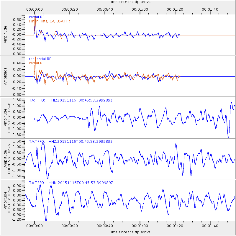
TPFO Pinon Flats, CA, USA - Earthquake Result Viewer
*The percent match for this event was below the threshold and hence no stack was calculated.
| Earthquake location: |
North Of Honduras |
| Earthquake latitude/longitude: |
17.8/-81.8 |
| Earthquake time(UTC): |
2015/11/16 (320) 00:39:33 GMT |
| Earthquake Depth: |
9.1 km |
| Earthquake Magnitude: |
5.8 MWP |
| Earthquake Catalog/Contributor: |
NEIC PDE/NEIC COMCAT |
|
| Network: |
TA USArray Transportable Network (new EarthScope stations) |
| Station: |
TPFO Pinon Flats, CA, USA |
| Lat/Lon: |
33.61 N/116.45 W |
| Elevation: |
1275 m |
|
| Distance: |
34.7 deg |
| Az: |
303.646 deg |
| Baz: |
108.177 deg |
| Ray Param: |
$rayparam |
*The percent match for this event was below the threshold and hence was not used in the summary stack. |
|
| Radial Match: |
59.627926 % |
| Radial Bump: |
301 |
| Transverse Match: |
50.167908 % |
| Transverse Bump: |
254 |
| SOD ConfigId: |
7422571 |
| Insert Time: |
2019-04-21 09:22:45.418 +0000 |
| GWidth: |
2.5 |
| Max Bumps: |
400 |
| Tol: |
0.001 |
|
Signal To Noise
| Channel | StoN | STA | LTA |
| TA:TPFO: :HHZ:20151116T00:45:53.399989Z | 1.711898 | 7.637195E-7 | 4.4612443E-7 |
| TA:TPFO: :HHN:20151116T00:45:53.399989Z | 2.6910815 | 5.6403644E-7 | 2.095947E-7 |
| TA:TPFO: :HHE:20151116T00:45:53.399989Z | 3.1434596 | 5.5143215E-7 | 1.7542206E-7 |
| Arrivals |
| Ps | |
| PpPs | |
| PsPs/PpSs | |


