You are here: Home > Network List > UW - Pacific Northwest Regional Seismic Network Stations List
> Station LTY Liberty (broad-band) > Earthquake Result Viewer
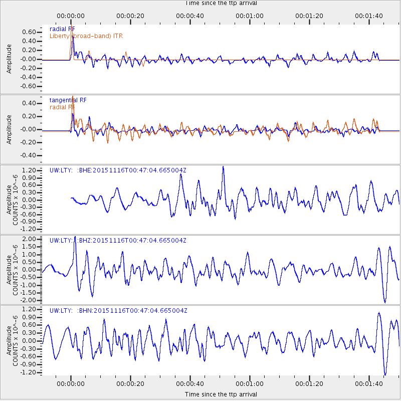
LTY Liberty (broad-band) - Earthquake Result Viewer
*The percent match for this event was below the threshold and hence no stack was calculated.
| Earthquake location: |
North Of Honduras |
| Earthquake latitude/longitude: |
17.8/-81.8 |
| Earthquake time(UTC): |
2015/11/16 (320) 00:39:33 GMT |
| Earthquake Depth: |
9.1 km |
| Earthquake Magnitude: |
5.8 MWP |
| Earthquake Catalog/Contributor: |
NEIC PDE/NEIC COMCAT |
|
| Network: |
UW Pacific Northwest Regional Seismic Network |
| Station: |
LTY Liberty (broad-band) |
| Lat/Lon: |
47.26 N/120.66 W |
| Elevation: |
970 m |
|
| Distance: |
43.2 deg |
| Az: |
321.437 deg |
| Baz: |
119.349 deg |
| Ray Param: |
$rayparam |
*The percent match for this event was below the threshold and hence was not used in the summary stack. |
|
| Radial Match: |
61.621384 % |
| Radial Bump: |
400 |
| Transverse Match: |
59.63994 % |
| Transverse Bump: |
400 |
| SOD ConfigId: |
7422571 |
| Insert Time: |
2019-04-21 09:23:04.462 +0000 |
| GWidth: |
2.5 |
| Max Bumps: |
400 |
| Tol: |
0.001 |
|
Signal To Noise
| Channel | StoN | STA | LTA |
| UW:LTY: :BHZ:20151116T00:47:04.665004Z | 2.3654373 | 9.23812E-7 | 3.9054598E-7 |
| UW:LTY: :BHN:20151116T00:47:04.665004Z | 0.9532754 | 3.341866E-7 | 3.505667E-7 |
| UW:LTY: :BHE:20151116T00:47:04.665004Z | 1.5312752 | 3.259821E-7 | 2.1288277E-7 |
| Arrivals |
| Ps | |
| PpPs | |
| PsPs/PpSs | |


