You are here: Home > Network List > UW - Pacific Northwest Regional Seismic Network Stations List
> Station OMAK Colville Reservation, Omak, WA, USA > Earthquake Result Viewer
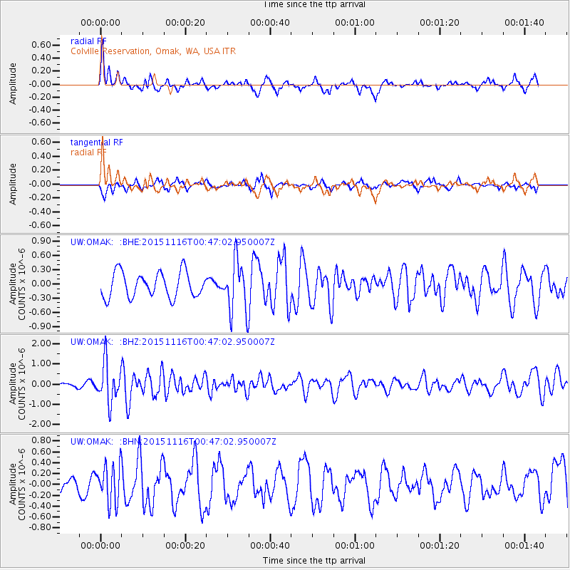
OMAK Colville Reservation, Omak, WA, USA - Earthquake Result Viewer
*The percent match for this event was below the threshold and hence no stack was calculated.
| Earthquake location: |
North Of Honduras |
| Earthquake latitude/longitude: |
17.8/-81.8 |
| Earthquake time(UTC): |
2015/11/16 (320) 00:39:33 GMT |
| Earthquake Depth: |
9.1 km |
| Earthquake Magnitude: |
5.8 MWP |
| Earthquake Catalog/Contributor: |
NEIC PDE/NEIC COMCAT |
|
| Network: |
UW Pacific Northwest Regional Seismic Network |
| Station: |
OMAK Colville Reservation, Omak, WA, USA |
| Lat/Lon: |
48.36 N/119.33 W |
| Elevation: |
696 m |
|
| Distance: |
43.0 deg |
| Az: |
323.494 deg |
| Baz: |
121.834 deg |
| Ray Param: |
$rayparam |
*The percent match for this event was below the threshold and hence was not used in the summary stack. |
|
| Radial Match: |
69.14682 % |
| Radial Bump: |
343 |
| Transverse Match: |
59.551193 % |
| Transverse Bump: |
352 |
| SOD ConfigId: |
7422571 |
| Insert Time: |
2019-04-21 09:23:04.691 +0000 |
| GWidth: |
2.5 |
| Max Bumps: |
400 |
| Tol: |
0.001 |
|
Signal To Noise
| Channel | StoN | STA | LTA |
| UW:OMAK: :BHZ:20151116T00:47:02.950007Z | 3.7899 | 1.0021325E-6 | 2.644219E-7 |
| UW:OMAK: :BHN:20151116T00:47:02.950007Z | 2.3752868 | 3.619981E-7 | 1.5240185E-7 |
| UW:OMAK: :BHE:20151116T00:47:02.950007Z | 1.9254875 | 5.128297E-7 | 2.6633757E-7 |
| Arrivals |
| Ps | |
| PpPs | |
| PsPs/PpSs | |


