You are here: Home > Network List > UW - Pacific Northwest Regional Seismic Network Stations List
> Station UMAT Pilot Rock, OR, USA > Earthquake Result Viewer
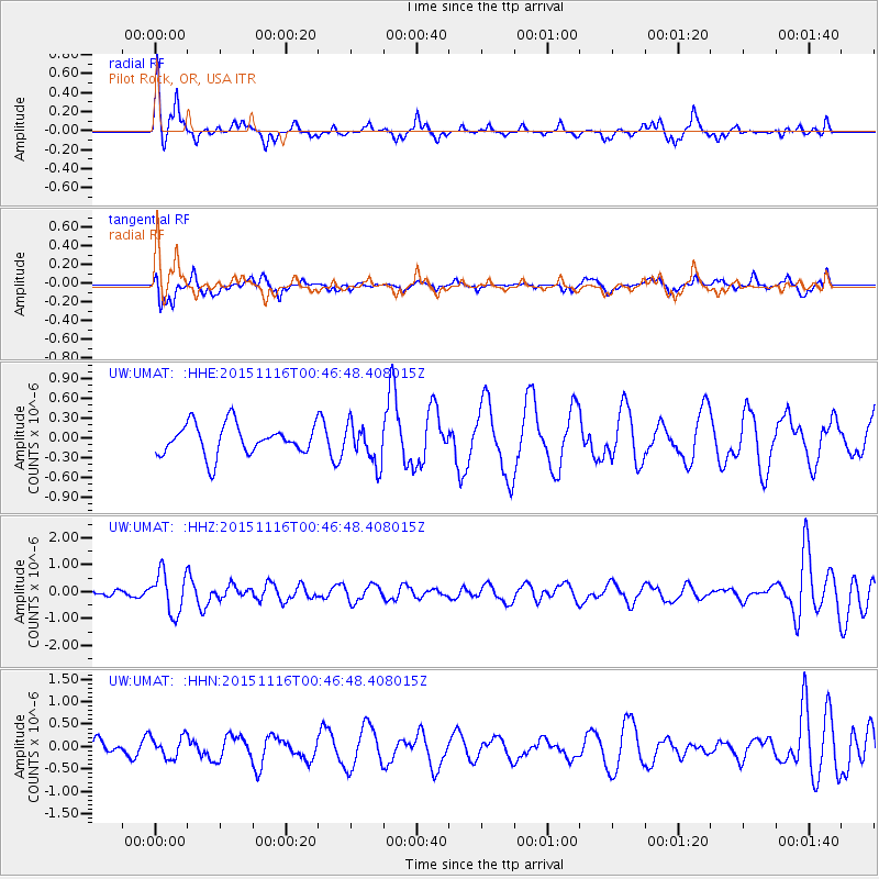
UMAT Pilot Rock, OR, USA - Earthquake Result Viewer
*The percent match for this event was below the threshold and hence no stack was calculated.
| Earthquake location: |
North Of Honduras |
| Earthquake latitude/longitude: |
17.8/-81.8 |
| Earthquake time(UTC): |
2015/11/16 (320) 00:39:33 GMT |
| Earthquake Depth: |
9.1 km |
| Earthquake Magnitude: |
5.8 MWP |
| Earthquake Catalog/Contributor: |
NEIC PDE/NEIC COMCAT |
|
| Network: |
UW Pacific Northwest Regional Seismic Network |
| Station: |
UMAT Pilot Rock, OR, USA |
| Lat/Lon: |
45.29 N/118.96 W |
| Elevation: |
1318 m |
|
| Distance: |
41.2 deg |
| Az: |
319.751 deg |
| Baz: |
119.329 deg |
| Ray Param: |
$rayparam |
*The percent match for this event was below the threshold and hence was not used in the summary stack. |
|
| Radial Match: |
54.09473 % |
| Radial Bump: |
283 |
| Transverse Match: |
40.244556 % |
| Transverse Bump: |
377 |
| SOD ConfigId: |
7422571 |
| Insert Time: |
2019-04-21 09:23:08.208 +0000 |
| GWidth: |
2.5 |
| Max Bumps: |
400 |
| Tol: |
0.001 |
|
Signal To Noise
| Channel | StoN | STA | LTA |
| UW:UMAT: :HHZ:20151116T00:46:48.408015Z | 3.4527032 | 7.551336E-7 | 2.1870792E-7 |
| UW:UMAT: :HHN:20151116T00:46:48.408015Z | 0.8141038 | 2.4245537E-7 | 2.9781876E-7 |
| UW:UMAT: :HHE:20151116T00:46:48.408015Z | 1.2872794 | 2.915991E-7 | 2.2652354E-7 |
| Arrivals |
| Ps | |
| PpPs | |
| PsPs/PpSs | |


