You are here: Home > Network List > IC - New China Digital Seismograph Network Stations List
> Station ENH Enshi, Hubei Province, China > Earthquake Result Viewer
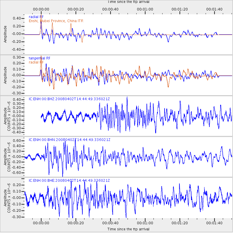
ENH Enshi, Hubei Province, China - Earthquake Result Viewer
*The percent match for this event was below the threshold and hence no stack was calculated.
| Earthquake location: |
Chagos Archipelago Region |
| Earthquake latitude/longitude: |
-4.9/69.2 |
| Earthquake time(UTC): |
2008/04/02 (093) 14:36:10 GMT |
| Earthquake Depth: |
10 km |
| Earthquake Magnitude: |
5.5 MB, 5.3 MS, 5.7 MW, 5.7 MW |
| Earthquake Catalog/Contributor: |
WHDF/NEIC |
|
| Network: |
IC New China Digital Seismograph Network |
| Station: |
ENH Enshi, Hubei Province, China |
| Lat/Lon: |
30.27 N/109.49 E |
| Elevation: |
487 m |
|
| Distance: |
52.0 deg |
| Az: |
45.173 deg |
| Baz: |
234.775 deg |
| Ray Param: |
$rayparam |
*The percent match for this event was below the threshold and hence was not used in the summary stack. |
|
| Radial Match: |
62.505814 % |
| Radial Bump: |
400 |
| Transverse Match: |
60.749016 % |
| Transverse Bump: |
400 |
| SOD ConfigId: |
2504 |
| Insert Time: |
2010-03-04 21:59:14.223 +0000 |
| GWidth: |
2.5 |
| Max Bumps: |
400 |
| Tol: |
0.001 |
|
Signal To Noise
| Channel | StoN | STA | LTA |
| IC:ENH:00:BHN:20080402T14:44:49.336021Z | 3.3805788 | 2.3327084E-7 | 6.900323E-8 |
| IC:ENH:00:BHE:20080402T14:44:49.336021Z | 1.3170574 | 7.412086E-8 | 5.6277624E-8 |
| IC:ENH:00:BHZ:20080402T14:44:49.336021Z | 1.7626328 | 1.2721797E-7 | 7.217497E-8 |
| Arrivals |
| Ps | |
| PpPs | |
| PsPs/PpSs | |


