You are here: Home > Network List > IC - New China Digital Seismograph Network Stations List
> Station ENH Enshi, Hubei Province, China > Earthquake Result Viewer
ENH Enshi, Hubei Province, China - Earthquake Result Viewer
*The percent match for this event was below the threshold and hence no stack was calculated.
| Earthquake location: |
Banda Sea |
| Earthquake latitude/longitude: |
-7.0/129.2 |
| Earthquake time(UTC): |
2008/04/02 (093) 19:10:19 GMT |
| Earthquake Depth: |
181 km |
| Earthquake Magnitude: |
5.5 MB, 5.7 MW, 5.7 MW |
| Earthquake Catalog/Contributor: |
WHDF/NEIC |
|
| Network: |
IC New China Digital Seismograph Network |
| Station: |
ENH Enshi, Hubei Province, China |
| Lat/Lon: |
30.27 N/109.49 E |
| Elevation: |
487 m |
|
| Distance: |
41.7 deg |
| Az: |
333.95 deg |
| Baz: |
149.746 deg |
| Ray Param: |
$rayparam |
*The percent match for this event was below the threshold and hence was not used in the summary stack. |
|
| Radial Match: |
76.084274 % |
| Radial Bump: |
400 |
| Transverse Match: |
57.118156 % |
| Transverse Bump: |
400 |
| SOD ConfigId: |
2504 |
| Insert Time: |
2010-03-04 21:59:19.605 +0000 |
| GWidth: |
2.5 |
| Max Bumps: |
400 |
| Tol: |
0.001 |
|
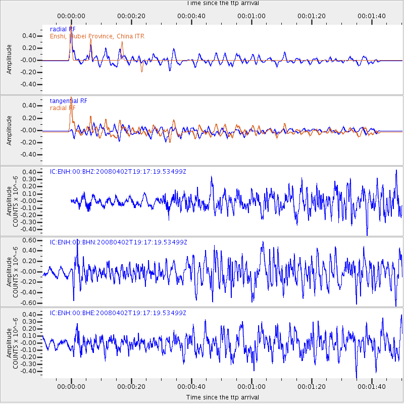
Signal To Noise
| Channel | StoN | STA | LTA |
| IC:ENH:00:BHN:20080402T19:17:19.53499Z | 3.602955 | 2.113334E-7 | 5.8655573E-8 |
| IC:ENH:00:BHE:20080402T19:17:19.53499Z | 2.201327 | 1.0355093E-7 | 4.7040228E-8 |
| IC:ENH:00:BHZ:20080402T19:17:19.53499Z | 1.4003195 | 7.087942E-8 | 5.061661E-8 |
| Arrivals |
| Ps | |
| PpPs | |
| PsPs/PpSs | |


