You are here: Home > Network List > CI - Caltech Regional Seismic Network Stations List
> Station EDW2 EDW2, Mojave, CA, USA > Earthquake Result Viewer
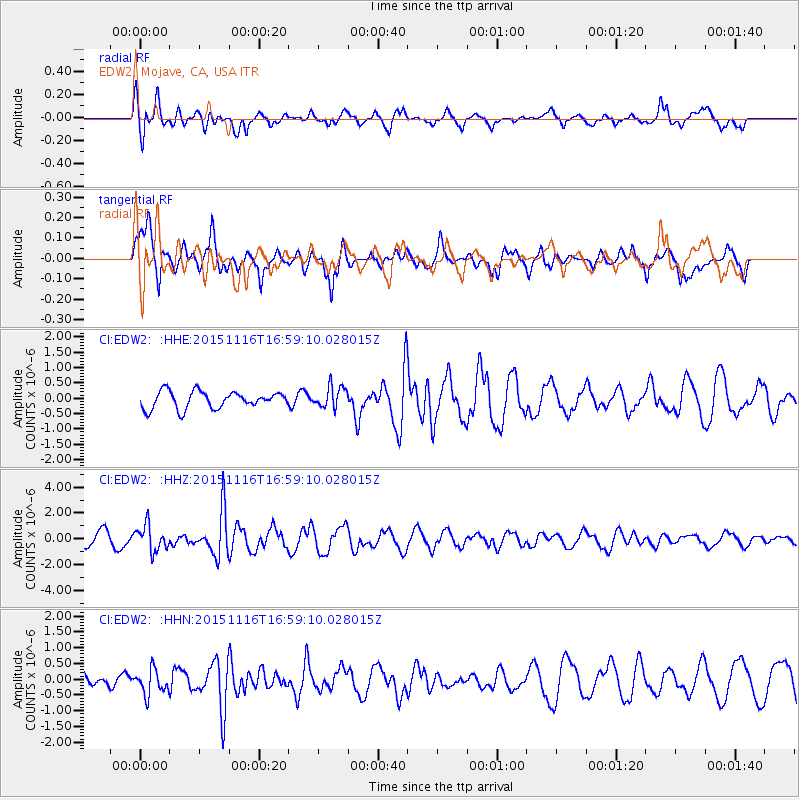
EDW2 EDW2, Mojave, CA, USA - Earthquake Result Viewer
*The percent match for this event was below the threshold and hence no stack was calculated.
| Earthquake location: |
Kuril Islands |
| Earthquake latitude/longitude: |
48.3/154.3 |
| Earthquake time(UTC): |
2015/11/16 (320) 16:49:15 GMT |
| Earthquake Depth: |
42 km |
| Earthquake Magnitude: |
5.8 MWB |
| Earthquake Catalog/Contributor: |
NEIC PDE/NEIC COMCAT |
|
| Network: |
CI Caltech Regional Seismic Network |
| Station: |
EDW2 EDW2, Mojave, CA, USA |
| Lat/Lon: |
34.88 N/117.99 W |
| Elevation: |
772 m |
|
| Distance: |
63.6 deg |
| Az: |
66.568 deg |
| Baz: |
311.819 deg |
| Ray Param: |
$rayparam |
*The percent match for this event was below the threshold and hence was not used in the summary stack. |
|
| Radial Match: |
65.991394 % |
| Radial Bump: |
400 |
| Transverse Match: |
75.69253 % |
| Transverse Bump: |
400 |
| SOD ConfigId: |
7422571 |
| Insert Time: |
2019-04-21 09:27:32.127 +0000 |
| GWidth: |
2.5 |
| Max Bumps: |
400 |
| Tol: |
0.001 |
|
Signal To Noise
| Channel | StoN | STA | LTA |
| CI:EDW2: :HHZ:20151116T16:59:10.028015Z | 1.5050584 | 9.858866E-7 | 6.5504867E-7 |
| CI:EDW2: :HHN:20151116T16:59:10.028015Z | 1.0608824 | 3.9639926E-7 | 3.736505E-7 |
| CI:EDW2: :HHE:20151116T16:59:10.028015Z | 1.2699994 | 3.509833E-7 | 2.7636494E-7 |
| Arrivals |
| Ps | |
| PpPs | |
| PsPs/PpSs | |


