You are here: Home > Network List > CI - Caltech Regional Seismic Network Stations List
> Station SLA SLA, Trona, CA, USA > Earthquake Result Viewer
SLA SLA, Trona, CA, USA - Earthquake Result Viewer
*The percent match for this event was below the threshold and hence no stack was calculated.
| Earthquake location: |
Kuril Islands |
| Earthquake latitude/longitude: |
48.3/154.3 |
| Earthquake time(UTC): |
2015/11/16 (320) 16:49:15 GMT |
| Earthquake Depth: |
42 km |
| Earthquake Magnitude: |
5.8 MWB |
| Earthquake Catalog/Contributor: |
NEIC PDE/NEIC COMCAT |
|
| Network: |
CI Caltech Regional Seismic Network |
| Station: |
SLA SLA, Trona, CA, USA |
| Lat/Lon: |
35.89 N/117.28 W |
| Elevation: |
1174 m |
|
| Distance: |
63.3 deg |
| Az: |
65.295 deg |
| Baz: |
311.66 deg |
| Ray Param: |
$rayparam |
*The percent match for this event was below the threshold and hence was not used in the summary stack. |
|
| Radial Match: |
67.63122 % |
| Radial Bump: |
400 |
| Transverse Match: |
61.80113 % |
| Transverse Bump: |
400 |
| SOD ConfigId: |
7422571 |
| Insert Time: |
2019-04-21 09:27:51.010 +0000 |
| GWidth: |
2.5 |
| Max Bumps: |
400 |
| Tol: |
0.001 |
|
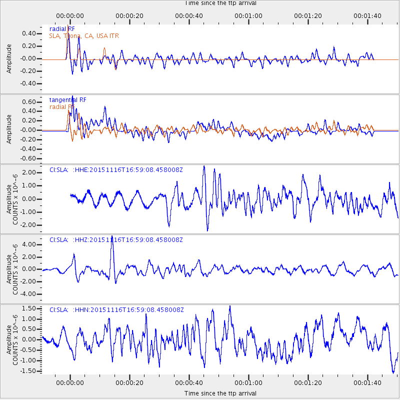
Signal To Noise
| Channel | StoN | STA | LTA |
| CI:SLA: :HHZ:20151116T16:59:08.458008Z | 3.007479 | 1.1625064E-6 | 3.865385E-7 |
| CI:SLA: :HHN:20151116T16:59:08.458008Z | 1.1577303 | 4.6354563E-7 | 4.003917E-7 |
| CI:SLA: :HHE:20151116T16:59:08.458008Z | 2.242926 | 8.657525E-7 | 3.8599245E-7 |
| Arrivals |
| Ps | |
| PpPs | |
| PsPs/PpSs | |


