You are here: Home > Network List > CI - Caltech Regional Seismic Network Stations List
> Station PAS Pasadena, Pasadena, CA, USA > Earthquake Result Viewer
PAS Pasadena, Pasadena, CA, USA - Earthquake Result Viewer
| Earthquake location: |
Kermadec Islands, New Zealand |
| Earthquake latitude/longitude: |
-30.6/-178.3 |
| Earthquake time(UTC): |
2003/05/04 (124) 20:08:46 GMT |
| Earthquake Depth: |
46 km |
| Earthquake Magnitude: |
6.0 MB, 6.1 MS, 6.4 MW, 6.4 MW |
| Earthquake Catalog/Contributor: |
WHDF/NEIC |
|
| Network: |
CI Caltech Regional Seismic Network |
| Station: |
PAS Pasadena, Pasadena, CA, USA |
| Lat/Lon: |
34.15 N/118.17 W |
| Elevation: |
314 m |
|
| Distance: |
85.8 deg |
| Az: |
46.139 deg |
| Baz: |
228.567 deg |
| Ray Param: |
0.04443854 |
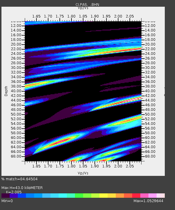
| Estimated Moho Depth: |
43.0 km |
| Estimated Crust Vp/Vs: |
2.09 |
| Assumed Crust Vp: |
6.1 km/s |
| Estimated Crust Vs: |
2.926 km/s |
| Estimated Crust Poisson's Ratio: |
0.35 |
|
| Radial Match: |
84.64504 % |
| Radial Bump: |
400 |
| Transverse Match: |
75.511856 % |
| Transverse Bump: |
400 |
| SOD ConfigId: |
3787 |
| Insert Time: |
2010-02-25 23:56:15.154 +0000 |
| GWidth: |
2.5 |
| Max Bumps: |
400 |
| Tol: |
0.001 |
|

Signal To Noise
| Channel | StoN | STA | LTA |
| CI:PAS: :BHN:20030504T20:20:49.836018Z | 1.6522962 | 3.0118971E-7 | 1.8228555E-7 |
| CI:PAS: :BHE:20030504T20:20:49.836018Z | 1.1049383 | 1.8516246E-7 | 1.6757721E-7 |
| CI:PAS: :BHZ:20030504T20:20:49.836018Z | 7.80241 | 1.1166599E-6 | 1.431173E-7 |
| Arrivals |
| Ps | 7.8 SECOND |
| PpPs | 21 SECOND |
| PsPs/PpSs | 29 SECOND |


