You are here: Home > Network List > IU - Global Seismograph Network (GSN - IRIS/USGS) Stations List
> Station GRFO Grafenberg, Germany > Earthquake Result Viewer
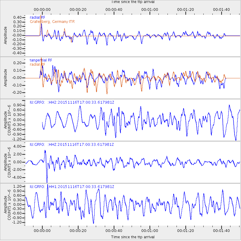
GRFO Grafenberg, Germany - Earthquake Result Viewer
*The percent match for this event was below the threshold and hence no stack was calculated.
| Earthquake location: |
Kuril Islands |
| Earthquake latitude/longitude: |
48.3/154.3 |
| Earthquake time(UTC): |
2015/11/16 (320) 16:49:15 GMT |
| Earthquake Depth: |
42 km |
| Earthquake Magnitude: |
5.8 MWB |
| Earthquake Catalog/Contributor: |
NEIC PDE/NEIC COMCAT |
|
| Network: |
IU Global Seismograph Network (GSN - IRIS/USGS) |
| Station: |
GRFO Grafenberg, Germany |
| Lat/Lon: |
49.69 N/11.22 E |
| Elevation: |
384 m |
|
| Distance: |
77.3 deg |
| Az: |
336.409 deg |
| Baz: |
24.299 deg |
| Ray Param: |
$rayparam |
*The percent match for this event was below the threshold and hence was not used in the summary stack. |
|
| Radial Match: |
56.581863 % |
| Radial Bump: |
400 |
| Transverse Match: |
67.35126 % |
| Transverse Bump: |
400 |
| SOD ConfigId: |
7422571 |
| Insert Time: |
2019-04-21 09:29:45.012 +0000 |
| GWidth: |
2.5 |
| Max Bumps: |
400 |
| Tol: |
0.001 |
|
Signal To Noise
| Channel | StoN | STA | LTA |
| IU:GRFO: :HHZ:20151116T17:00:33.617981Z | 6.9029045 | 1.8112828E-6 | 2.623943E-7 |
| IU:GRFO: :HH1:20151116T17:00:33.617981Z | 1.0801742 | 5.0745024E-7 | 4.697856E-7 |
| IU:GRFO: :HH2:20151116T17:00:33.617981Z | 1.3187355 | 4.850821E-7 | 3.6783882E-7 |
| Arrivals |
| Ps | |
| PpPs | |
| PsPs/PpSs | |


