You are here: Home > Network List > IC - New China Digital Seismograph Network Stations List
> Station ENH Enshi, Hubei Province, China > Earthquake Result Viewer
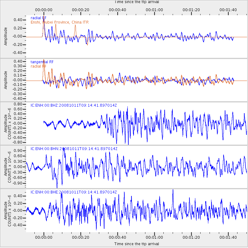
ENH Enshi, Hubei Province, China - Earthquake Result Viewer
*The percent match for this event was below the threshold and hence no stack was calculated.
| Earthquake location: |
Eastern Caucasus |
| Earthquake latitude/longitude: |
43.4/46.3 |
| Earthquake time(UTC): |
2008/10/11 (285) 09:06:10 GMT |
| Earthquake Depth: |
16 km |
| Earthquake Magnitude: |
5.6 MB, 5.5 MS, 5.8 MW, 5.7 MW |
| Earthquake Catalog/Contributor: |
WHDF/NEIC |
|
| Network: |
IC New China Digital Seismograph Network |
| Station: |
ENH Enshi, Hubei Province, China |
| Lat/Lon: |
30.27 N/109.49 E |
| Elevation: |
487 m |
|
| Distance: |
51.1 deg |
| Az: |
82.686 deg |
| Baz: |
303.275 deg |
| Ray Param: |
$rayparam |
*The percent match for this event was below the threshold and hence was not used in the summary stack. |
|
| Radial Match: |
62.523106 % |
| Radial Bump: |
400 |
| Transverse Match: |
65.49647 % |
| Transverse Bump: |
400 |
| SOD ConfigId: |
2556 |
| Insert Time: |
2010-03-04 21:59:58.021 +0000 |
| GWidth: |
2.5 |
| Max Bumps: |
400 |
| Tol: |
0.001 |
|
Signal To Noise
| Channel | StoN | STA | LTA |
| IC:ENH:00:BHN:20081011T09:14:41.897014Z | 2.5228095 | 2.8293596E-7 | 1.12151135E-7 |
| IC:ENH:00:BHE:20081011T09:14:41.897014Z | 1.6531789 | 1.2289894E-7 | 7.4340974E-8 |
| IC:ENH:00:BHZ:20081011T09:14:41.897014Z | 2.0869212 | 1.8230295E-7 | 8.7354984E-8 |
| Arrivals |
| Ps | |
| PpPs | |
| PsPs/PpSs | |


