You are here: Home > Network List > IC - New China Digital Seismograph Network Stations List
> Station ENH Enshi, Hubei Province, China > Earthquake Result Viewer
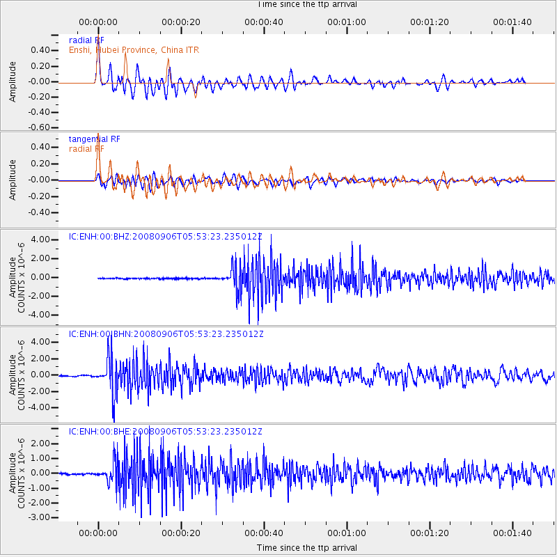
ENH Enshi, Hubei Province, China - Earthquake Result Viewer
*The percent match for this event was below the threshold and hence no stack was calculated.
| Earthquake location: |
Hindu Kush Region, Afghanistan |
| Earthquake latitude/longitude: |
36.5/70.9 |
| Earthquake time(UTC): |
2008/09/06 (250) 05:47:39 GMT |
| Earthquake Depth: |
192 km |
| Earthquake Magnitude: |
5.5 MB, 5.8 MW, 5.8 MW |
| Earthquake Catalog/Contributor: |
WHDF/NEIC |
|
| Network: |
IC New China Digital Seismograph Network |
| Station: |
ENH Enshi, Hubei Province, China |
| Lat/Lon: |
30.27 N/109.49 E |
| Elevation: |
487 m |
|
| Distance: |
32.6 deg |
| Az: |
89.611 deg |
| Baz: |
291.326 deg |
| Ray Param: |
$rayparam |
*The percent match for this event was below the threshold and hence was not used in the summary stack. |
|
| Radial Match: |
72.02485 % |
| Radial Bump: |
400 |
| Transverse Match: |
68.56809 % |
| Transverse Bump: |
400 |
| SOD ConfigId: |
2560 |
| Insert Time: |
2010-03-04 22:00:03.356 +0000 |
| GWidth: |
2.5 |
| Max Bumps: |
400 |
| Tol: |
0.001 |
|
Signal To Noise
| Channel | StoN | STA | LTA |
| IC:ENH:00:BHN:20080906T05:53:23.235012Z | 46.409386 | 2.2203224E-6 | 4.7842097E-8 |
| IC:ENH:00:BHE:20080906T05:53:23.235012Z | 15.354045 | 7.168559E-7 | 4.6688406E-8 |
| IC:ENH:00:BHZ:20080906T05:53:23.235012Z | 26.85 | 1.203428E-6 | 4.482041E-8 |
| Arrivals |
| Ps | |
| PpPs | |
| PsPs/PpSs | |


