You are here: Home > Network List > IC - New China Digital Seismograph Network Stations List
> Station ENH Enshi, Hubei Province, China > Earthquake Result Viewer
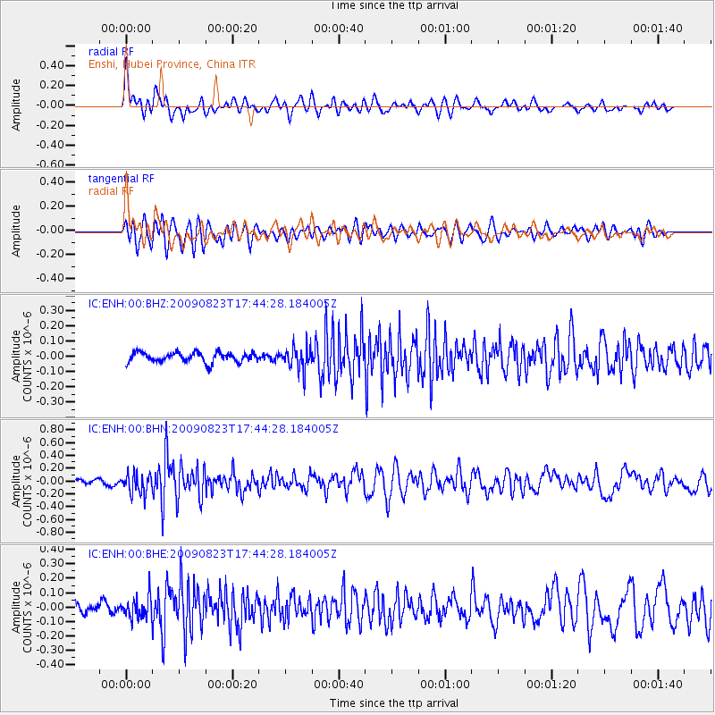
ENH Enshi, Hubei Province, China - Earthquake Result Viewer
*The percent match for this event was below the threshold and hence no stack was calculated.
| Earthquake location: |
Southern Sumatra, Indonesia |
| Earthquake latitude/longitude: |
-1.6/99.6 |
| Earthquake time(UTC): |
2009/08/23 (235) 17:38:23 GMT |
| Earthquake Depth: |
18 km |
| Earthquake Magnitude: |
5.6 MB, 5.1 MS, 5.4 MW, 5.4 MW |
| Earthquake Catalog/Contributor: |
WHDF/NEIC |
|
| Network: |
IC New China Digital Seismograph Network |
| Station: |
ENH Enshi, Hubei Province, China |
| Lat/Lon: |
30.27 N/109.49 E |
| Elevation: |
487 m |
|
| Distance: |
33.1 deg |
| Az: |
15.819 deg |
| Baz: |
198.36 deg |
| Ray Param: |
$rayparam |
*The percent match for this event was below the threshold and hence was not used in the summary stack. |
|
| Radial Match: |
69.54578 % |
| Radial Bump: |
400 |
| Transverse Match: |
75.891846 % |
| Transverse Bump: |
400 |
| SOD ConfigId: |
2622 |
| Insert Time: |
2010-03-04 22:00:22.851 +0000 |
| GWidth: |
2.5 |
| Max Bumps: |
400 |
| Tol: |
0.001 |
|
Signal To Noise
| Channel | StoN | STA | LTA |
| IC:ENH:00:BHN:20090823T17:44:28.184005Z | 3.2251828 | 1.5718811E-7 | 4.873774E-8 |
| IC:ENH:00:BHE:20090823T17:44:28.184005Z | 2.6563551 | 7.369075E-8 | 2.77413E-8 |
| IC:ENH:00:BHZ:20090823T17:44:28.184005Z | 2.4058373 | 7.568561E-8 | 3.1459155E-8 |
| Arrivals |
| Ps | |
| PpPs | |
| PsPs/PpSs | |


