You are here: Home > Network List > PE - Penn State Network Stations List
> Station PAGS PA Geological Survey, Middletown, PA > Earthquake Result Viewer
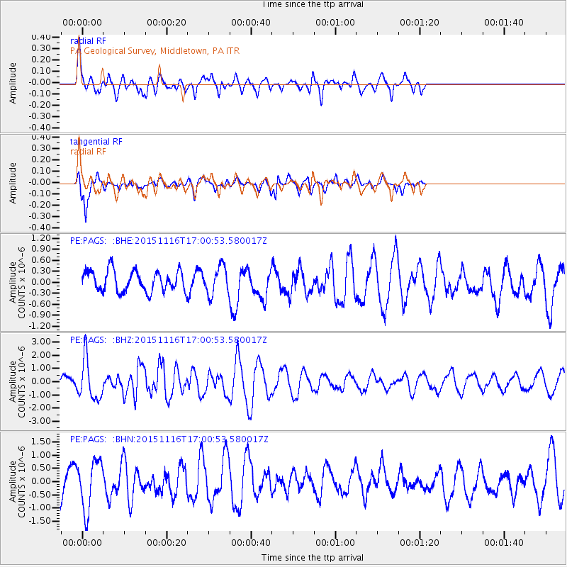
PAGS PA Geological Survey, Middletown, PA - Earthquake Result Viewer
*The percent match for this event was below the threshold and hence no stack was calculated.
| Earthquake location: |
Kuril Islands |
| Earthquake latitude/longitude: |
48.3/154.3 |
| Earthquake time(UTC): |
2015/11/16 (320) 16:49:15 GMT |
| Earthquake Depth: |
42 km |
| Earthquake Magnitude: |
5.8 MWB |
| Earthquake Catalog/Contributor: |
NEIC PDE/NEIC COMCAT |
|
| Network: |
PE Penn State Network |
| Station: |
PAGS PA Geological Survey, Middletown, PA |
| Lat/Lon: |
40.23 N/76.72 W |
| Elevation: |
120 m |
|
| Distance: |
81.0 deg |
| Az: |
37.036 deg |
| Baz: |
328.308 deg |
| Ray Param: |
$rayparam |
*The percent match for this event was below the threshold and hence was not used in the summary stack. |
|
| Radial Match: |
70.114 % |
| Radial Bump: |
400 |
| Transverse Match: |
80.84323 % |
| Transverse Bump: |
400 |
| SOD ConfigId: |
7422571 |
| Insert Time: |
2019-04-21 09:34:59.938 +0000 |
| GWidth: |
2.5 |
| Max Bumps: |
400 |
| Tol: |
0.001 |
|
Signal To Noise
| Channel | StoN | STA | LTA |
| PE:PAGS: :BHZ:20151116T17:00:53.580017Z | 3.4959416 | 1.5351471E-6 | 4.3912266E-7 |
| PE:PAGS: :BHN:20151116T17:00:53.580017Z | 1.8643328 | 9.468433E-7 | 5.0787247E-7 |
| PE:PAGS: :BHE:20151116T17:00:53.580017Z | 1.6579187 | 4.806739E-7 | 2.899261E-7 |
| Arrivals |
| Ps | |
| PpPs | |
| PsPs/PpSs | |


