You are here: Home > Network List > TA - USArray Transportable Network (new EarthScope stations) Stations List
> Station BGNE Belgrade, NE, USA > Earthquake Result Viewer
BGNE Belgrade, NE, USA - Earthquake Result Viewer
*The percent match for this event was below the threshold and hence no stack was calculated.
| Earthquake location: |
Kuril Islands |
| Earthquake latitude/longitude: |
48.3/154.3 |
| Earthquake time(UTC): |
2015/11/16 (320) 16:49:15 GMT |
| Earthquake Depth: |
42 km |
| Earthquake Magnitude: |
5.8 MWB |
| Earthquake Catalog/Contributor: |
NEIC PDE/NEIC COMCAT |
|
| Network: |
TA USArray Transportable Network (new EarthScope stations) |
| Station: |
BGNE Belgrade, NE, USA |
| Lat/Lon: |
41.41 N/98.15 W |
| Elevation: |
573 m |
|
| Distance: |
70.2 deg |
| Az: |
49.65 deg |
| Baz: |
317.425 deg |
| Ray Param: |
$rayparam |
*The percent match for this event was below the threshold and hence was not used in the summary stack. |
|
| Radial Match: |
70.63313 % |
| Radial Bump: |
400 |
| Transverse Match: |
64.5896 % |
| Transverse Bump: |
400 |
| SOD ConfigId: |
7422571 |
| Insert Time: |
2019-04-21 09:36:22.554 +0000 |
| GWidth: |
2.5 |
| Max Bumps: |
400 |
| Tol: |
0.001 |
|
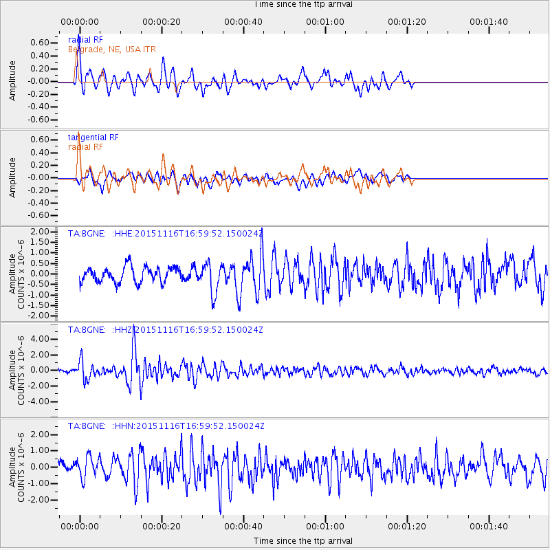
Signal To Noise
| Channel | StoN | STA | LTA |
| TA:BGNE: :HHZ:20151116T16:59:52.150024Z | 5.494483 | 1.1928664E-6 | 2.1710257E-7 |
| TA:BGNE: :HHN:20151116T16:59:52.150024Z | 2.4702256 | 6.829083E-7 | 2.7645584E-7 |
| TA:BGNE: :HHE:20151116T16:59:52.150024Z | 2.0559857 | 7.2721224E-7 | 3.537049E-7 |
| Arrivals |
| Ps | |
| PpPs | |
| PsPs/PpSs | |


