You are here: Home > Network List > TA - USArray Transportable Network (new EarthScope stations) Stations List
> Station I23K Minto, Yukon-Koyukuk, AK, USA > Earthquake Result Viewer
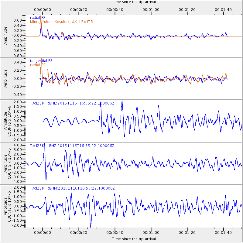
I23K Minto, Yukon-Koyukuk, AK, USA - Earthquake Result Viewer
*The percent match for this event was below the threshold and hence no stack was calculated.
| Earthquake location: |
Kuril Islands |
| Earthquake latitude/longitude: |
48.3/154.3 |
| Earthquake time(UTC): |
2015/11/16 (320) 16:49:15 GMT |
| Earthquake Depth: |
42 km |
| Earthquake Magnitude: |
5.8 MWB |
| Earthquake Catalog/Contributor: |
NEIC PDE/NEIC COMCAT |
|
| Network: |
TA USArray Transportable Network (new EarthScope stations) |
| Station: |
I23K Minto, Yukon-Koyukuk, AK, USA |
| Lat/Lon: |
65.15 N/149.36 W |
| Elevation: |
149 m |
|
| Distance: |
33.8 deg |
| Az: |
39.229 deg |
| Baz: |
267.883 deg |
| Ray Param: |
$rayparam |
*The percent match for this event was below the threshold and hence was not used in the summary stack. |
|
| Radial Match: |
73.68179 % |
| Radial Bump: |
400 |
| Transverse Match: |
69.94917 % |
| Transverse Bump: |
395 |
| SOD ConfigId: |
7422571 |
| Insert Time: |
2019-04-21 09:36:33.883 +0000 |
| GWidth: |
2.5 |
| Max Bumps: |
400 |
| Tol: |
0.001 |
|
Signal To Noise
| Channel | StoN | STA | LTA |
| TA:I23K: :BHZ:20151116T16:55:22.100006Z | 7.6149373 | 1.8034498E-6 | 2.3683054E-7 |
| TA:I23K: :BHN:20151116T16:55:22.100006Z | 1.946747 | 4.3277785E-7 | 2.2230823E-7 |
| TA:I23K: :BHE:20151116T16:55:22.100006Z | 2.9981878 | 7.4186045E-7 | 2.4743628E-7 |
| Arrivals |
| Ps | |
| PpPs | |
| PsPs/PpSs | |


